Back أولت (نهر) Arabic نهر اولت ARZ اولت چایی AZB Олт Byelorussian Олт Bulgarian Olt Breton Riu Olt Catalan Olt (suba) CEB Olt (řeka) Czech Olt Danish
| Olt | |
|---|---|
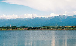
 The Avrig reservoir on the Olt | |
 | |
 | |
| Location | |
| Country | Romania |
| Counties | |
| Cities | |
| Physical characteristics | |
| Source | Hășmaș Mountains |
| • location | Bălan, Harghita |
| • elevation | 1,440 m (4,720 ft) |
| Mouth | Danube |
• location | near Turnu Măgurele |
• coordinates | 43°42′46″N 24°48′1″E / 43.71278°N 24.80028°E |
| Length | 615 km (382 mi) |
| Basin size | 24,050 km2 (9,290 sq mi) |
| Discharge | |
| • location | mouth |
| • average | 174 m3/s (6,100 cu ft/s) |
| Basin features | |
| Progression | Danube→ Black Sea |
| Tributaries | |
| • left | Râul Negru, Bârsa, Topolog |
| • right | Cormoș, Cibin, Lotru, Olteț |
| River code | VIII.1 |
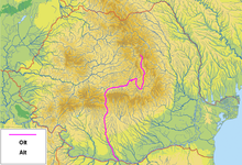
The Olt (Romanian and Hungarian; German: Alt; Latin: Aluta or Alutus, Turkish: Oltu, Ancient Greek: Ἄλυτος Alytos) is a river in Romania.[1][2] It is 615 km (382 mi) long, and its basin area is 24,050 km2 (9,290 sq mi).[2][3] It is the longest river flowing exclusively through Romania. Its average discharge at the mouth is 174 m3/s (6,100 cu ft/s).[3] It originates in the Hășmaș Mountains of the eastern Carpathian Mountains, near Bălan, rising close to the headwaters of the river Mureș. The Olt flows through the Romanian counties of Harghita, Covasna, Brașov, Sibiu, Vâlcea, and Olt. The river was known as Alutus or Aluta in Roman antiquity. Olt County and the historical province of Oltenia are named after the river.
Sfântu Gheorghe, Râmnicu Vâlcea and Slatina are the main cities on the river Olt. The Olt flows into the Danube river near Turnu Măgurele.
- ^ "Planul național de management. Sinteza planurilor de management la nivel de bazine/spații hidrografice, anexa 7.1" (PDF, 5.1 MB). Administrația Națională Apele Române. 2010. pp. 635–638.
- ^ a b Atlasul cadastrului apelor din România. Partea 1 (in Romanian). Bucharest: Ministerul Mediului. 1992. pp. 263–308. OCLC 895459847. River code: VIII.1
- ^ a b "Danube River Basin District, Part A - Roof Report" (PDF). ICPDR. April 2004. p. 12.