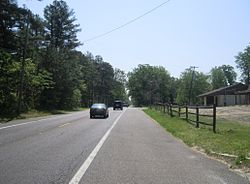
Ong's Hat, New Jersey | |
|---|---|
Former village | |
 Along Magnolia Road (CR 644) | |
| Coordinates: 39°54′39″N 74°37′15″W / 39.91083°N 74.62083°W | |
| Country | |
| State | |
| County | Burlington |
| Township | Pemberton |
| Elevation | 30 m (98 ft) |
| Time zone | UTC−05:00 (Eastern (EST)) |
| • Summer (DST) | UTC−04:00 (Eastern (EDT)) |
| GNIS feature ID | 878993[1] |
Ong's Hat (also Ong) is a ghost town in Pemberton Township, Burlington County, in the U.S. state of New Jersey.[2] It is located on Magnolia Road (County Route 644) west of the Four Mile Circle, where New Jersey Route 72 intersects with New Jersey Route 70.[3] It is the northern terminus of the Batona Trail.
Although it was never more than one hut ("Ong's Hut"), it still appeared on some maps as of 2006.[4] A road in the area is named Ong's Hat Road. It is also called the Buddtown-Ong's Hat Road. It was completed in 1929, replacing an earlier dirt path.[5]
- ^ a b U.S. Geological Survey Geographic Names Information System: Ong's Hat, New Jersey
- ^ Locality Search, State of New Jersey. Accessed December 14, 2014.
- ^ Sceurman, Mark (2006). "Weird N.J. Volume 2". Sterling Publishing Company. pp. 68–69. ISBN 1-4027-3941-9.
- ^ Scheller, Kay (2006). New Jersey Off the Beaten Path (8th ed.). Globe Pequot. p. 145. ISBN 0-7627-4055-8.
- ^ Dickinson, Leon A. "IT'S THE SEASON NOW UP IN THE CATSKILLS; Good Roads Make Many Resorts Easily Accessible to Trippers and Vacationists--Road Conditions in New York, Pennsylvania and Vermont--Other Highway News" (subscription required), The New York Times, June 23, 1929. Accessed December 14, 2014. "A new road between Buddtown and Ong's Hat, in Burlington county, is now open for traffic."


