Back مقاطعة أونونداغا (نيويورك) Arabic Onondaga County, New York BAR Онондага (окръг, Ню Йорк) Bulgarian ওনোন্দাগা কাউন্টি, নিউ ইয়র্ক BPY Onondaga Gông (New York) CDO Онондага (гуо, Нью-Йорк) CE Onondaga County CEB Onondaga County Czech Onondaga County, Efrog Newydd Welsh Onondaga County German
Onondaga County | |
|---|---|
 Onondaga County Courthouse at Columbus Circle in Syracuse | |
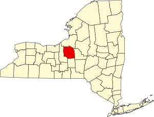
 Location within the U.S. state of New York | |
 New York's location within the U.S. | |
| Coordinates: 43°01′N 76°12′W / 43.01°N 76.2°W | |
| Country | |
| State | |
| Founded | 1794 |
| Named for | Onondaga people |
| Seat | Syracuse |
| Largest city | Syracuse |
| Government | |
| • County Executive | J. Ryan McMahon II (R) |
| Area | |
• Total | 806 sq mi (2,090 km2) |
| • Land | 778 sq mi (2,020 km2) |
| • Water | 27 sq mi (70 km2) 3.4% |
| Population (2020) | |
• Total | 476,516 |
| • Density | 600/sq mi (200/km2) |
| Time zone | UTC−5 (Eastern) |
| • Summer (DST) | UTC−4 (EDT) |
| Congressional district | 22nd |
| Website | ongov.net |
Onondaga County (/ˌɒnənˈdɑːɡə/ ON-ən-DAH-gə) is a county in the U.S. state of New York. As of the 2020 census, the population was 476,516.[1] The county seat is Syracuse.[2] The county is part of the Central New York region of the state.
Onondaga County is the core of the Syracuse Metropolitan Statistical Area.
- ^ "US Census Bureau QuickFacts". Retrieved August 29, 2021.
- ^ "Find a County". National Association of Counties. Archived from the original on May 31, 2011. Retrieved June 7, 2011.

