Back مقاطعة أوتيرو (نيومكسيكو) Arabic Otero County, New Mexico BAR Отеро (окръг, Ню Мексико) Bulgarian ওটেরো কাউন্টি, নিউ মেক্সিকো BPY Otero Gông (New Mexico) CDO Отеро (гуо, Нью-Мексико) CE Otero County (kondado sa Tinipong Bansa, New Mexico) CEB Otero County, Mecsico Newydd Welsh Otero County (New Mexico) German Condado de Otero (Nuevo México) Spanish
Otero County | |
|---|---|
 Otero County courthouse in Alamogordo | |
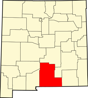
 Location within the U.S. state of New Mexico | |
 New Mexico's location within the U.S. | |
| Coordinates: 32°37′N 105°44′W / 32.62°N 105.73°W | |
| Country | |
| State | |
| Founded | January 30, 1899 |
| Named for | Miguel Antonio Otero |
| Seat | Alamogordo |
| Largest city | Alamogordo |
| Area | |
• Total | 6,628 sq mi (17,170 km2) |
| • Land | 6,613 sq mi (17,130 km2) |
| • Water | 14 sq mi (40 km2) 0.2% |
| Population (2020) | |
• Total | 67,839 |
| • Density | 10/sq mi (4.0/km2) |
| Time zone | UTC−7 (Mountain) |
| • Summer (DST) | UTC−6 (MDT) |
| Congressional district | 2nd |
| Website | co |
Otero County (Spanish: Condado de Otero) is a county located in the U.S. state of New Mexico. As of the 2020 census, the population was 67,839.[1] Its county seat is Alamogordo.[2] Its southern boundary is the Texas state line. It is named for Miguel Antonio Otero, the territorial governor when the county was created.[3]
Otero County includes the Alamogordo Micropolitan Statistical Area.[4]
- ^ "Otero County, New Mexico". United States Census Bureau. Retrieved July 3, 2023.
- ^ "Find a County". National Association of Counties. Retrieved June 7, 2011.
- ^ Thompson, Mark. "Miguel Otero: Father, Son, and Grandson". New Mexico Office of the State Historian. Retrieved September 13, 2018.
- ^ "Alamogordo, NM Micropolitan Statistical Area" (PDF). US Census Bureau. December 2006. Archived (PDF) from the original on June 9, 2011. Retrieved September 9, 2009.
