Back Oxfordshire Afrikaans Oxfordshire AN Oxnafordsċīr ANG أكسفوردشير Arabic اوكسفوردشير ARZ Oxfordshire AST Oxfordshire BAN Оксфардшыр Byelorussian Оксфардшыр BE-X-OLD Оксфордшър Bulgarian
This article needs additional citations for verification. (December 2022) |
Oxfordshire | |
|---|---|
Clockwise from top left: the Radcliffe Camera, part of the University of Oxford; Islip, in the Cherwell district; and the Uffington White Horse | |
| Sovereign state | United Kingdom |
| Constituent country | England |
| Region | South East England |
| Time zone | UTC+0 (GMT) |
| • Summer (DST) | UTC+1 (BST) |
| UK Parliament | 7 Members of Parliament |
| Police | Thames Valley Police |
| Largest city | Oxford |
| Ceremonial county | |
| Lord Lieutenant | Marjorie Glasgow |
| High Sheriff | Amanda Ponsonby[1] (2020–21) |
| Area | 2,605 km2 (1,006 sq mi) |
| • Rank | 22nd of 48 |
| Population (2022)[2] | 738,276 |
| • Rank | 35th of 48 |
| Density | 283/km2 (730/sq mi) |
| Ethnicity | 90.9% White, 4.8% Asian/Asian British[3] |
| Non-metropolitan county | |
| County council | Oxfordshire County Council[4] |
| Control | No overall control |
| Admin HQ | Oxford |
| Area | 2,605 km2 (1,006 sq mi) |
| • Rank | 12th of 21 |
| Population (2022)[5] | 738,276 |
| • Rank | 15th of 21 |
| Density | 283/km2 (730/sq mi) |
| ISO 3166-2 | GB-OXF |
| GSS code | E10000025 |
| ITL | TLJ14 |
| Website | oxfordshire |
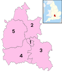
| Districts | |
 Districts of Oxfordshire | |
| Districts | |
Oxfordshire (/ˈɒksfərdʃər, -ʃɪər/ OKS-fərd-shər, -sheer; abbreviated Oxon) is a ceremonial county in South East England. The county is bordered by Northamptonshire and Warwickshire to the north, Buckinghamshire to the east, Berkshire to the south, and Wiltshire and Gloucestershire to the west. The city of Oxford is the largest settlement and county town.
The county is largely rural, with an area of 2,605 km2 (1,006 sq mi) and a population of 691,667. After Oxford (162,100), the largest settlements are Banbury (54,355) and Abingdon-on-Thames (37,931). For local government purposes Oxfordshire is a non-metropolitan county with five districts. The part of the county south of the River Thames, largely corresponding to the Vale of White Horse district, was historically part of Berkshire.
The lowlands in the centre of the county are crossed by the River Thames and its tributaries, the valleys of which are separated by low hills. The south contains parts of the Berkshire Downs and Chiltern Hills, and the north-west includes part of the Cotswolds; all three regions are Areas of Outstanding Natural Beauty. The county's highest point is White Horse Hill (261-metre (856 ft)), part of the Berkshire Downs.[6]
- ^ "No. 62943". The London Gazette. 13 March 2020. p. 5161.
- ^ "Mid-2022 population estimates by Lieutenancy areas (as at 1997) for England and Wales". Office for National Statistics. 24 June 2024. Retrieved 26 June 2024.
- ^ UK Census (2011). "Local Area Report – Oxfordshire Local Authority (E10000025)". Nomis. Office for National Statistics. Retrieved 2 July 2020.
- ^ "Homepage". Archived from the original on 23 November 2002. Retrieved 16 November 2002.
- ^ "Mid-Year Population Estimates, UK, June 2022". Office for National Statistics. 26 March 2024. Retrieved 3 May 2024.
- ^ Edwardes, Simon (2001). "County and Unitary Authority Tops". The Mountains of England and Wales. Archived from the original on 22 December 2015. Retrieved 14 December 2015.


