Back Pacific Ranges CEB Pacific Ranges Czech Pacific Ranges German Montañas del Pacífico Spanish Chaînons du Pacifique French Pacific Ranges Swedish
| Pacific Ranges | |
|---|---|
| French: Chaînons du Pacifique | |
 | |
| Highest point | |
| Peak | Mount Waddington |
| Elevation | 4,019 m (13,186 ft) |
| Coordinates | 51°22′30″N 125°15′30″W / 51.37500°N 125.25833°W |
| Dimensions | |
| Area | 108,237 km2 (41,791 sq mi) |
| Geography | |
| Location | British Columbia, Canada |
| Parent range | Coast Mountains |
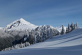
The Pacific Ranges are the southernmost subdivision of the Coast Mountains portion of the Pacific Cordillera. Located entirely within British Columbia, Canada, they run northwest from the lower stretches of the Fraser River to Bella Coola and Burke Channel,[1] north of which are the Kitimat Ranges. The Coast Mountains lie between the Interior Plateau and the Coast of British Columbia.[2][3]
The Pacific Ranges include four of the five major coastal icecaps in the southern Coast Mountains. These are the largest temperate-latitude icecaps in the world and fuel a number of very major rivers (by volume, not length). One of these contains Mount Waddington, the highest summit entirely within British Columbia. Also within this region is Hunlen Falls, among the highest in Canada, located in Tweedsmuir South Provincial Park.
Other than logging and various hydroelectric developments, and a large ski resort at Whistler, most of the land in the range is completely undeveloped. Historically, in the southern part of the range, mining was important at various times in the Lillooet, Bridge River and Squamish areas, and large pulp and paper mills at Powell River, Port Mellon and Woodfibre. The largest hydroelectric development in the Pacific Ranges is the Bridge River Power Project, though smaller hydro plants are on the Stave River-Alouette Lake system in Mission and Maple Ridge, the Daisy Lake-Squamish River division of the Cheakamus Powerhouse, and another power dam and power plant at Clowhom. Although the range was extensively surveyed for possible rail routes, only that of the Pacific Great Eastern (now part of CN) was eventually built; the Homathko River-Bute Inlet route, however, was one of the two main choices in the deliberations of the CPR's routing.
- ^ BC Names/GeoBC entry "Pacific Ranges"
- ^ "S. Holland, Landforms of British Columbia, Province of British Columbia, 1976, pp 42-43" (PDF). Archived from the original (PDF) on 2016-03-04. Retrieved 2014-04-26.
- ^ "map from Bulletin 48: Landforms of British Columbia" (PDF). Archived from the original (PDF) on 2016-03-03. Retrieved 2014-04-26.
