Back مضيق بالك Arabic Polk boğazı Azerbaijani Полк боғаҙы Bashkir Полкскі праліў Byelorussian Полкски проток Bulgarian पाक जलजोड़ Bihari পক প্রণালি Bengali/Bangla Strizh-mor Palk Breton Estret de Palk Catalan Palk Strait CEB
| Palk Strait | |
|---|---|
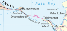
 Palk Strait separating Palk Bay from the Gulf of Mannar | |
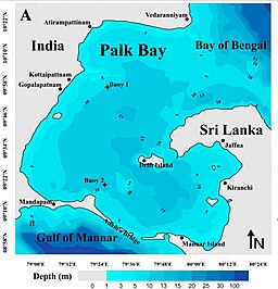
 Bathymetry of the Palk Strait, with water depth in metres | |
| Location | Bay of Bengal–Laccadive Sea |
| Coordinates | 10°00′N 79°45′E / 10.000°N 79.750°E |
| Type | Strait |
| Etymology | Robert Palk |
| Basin countries | India, Sri Lanka |
| Max. length | 137 km (85 mi) |
| Max. width | 137 km (85 mi) |
| Min. width | 64 km (40 mi) |
| Max. depth | 35 m (115 ft) |
| Settlements | Rameswaram Jaffna |
Palk Strait is a strait between the Indian state of Tamil Nadu and Northern Province of Sri Lanka. It connects the Palk Bay in the Bay of Bengal in the north with the Gulf of Mannar in the Laccadive sea in the south. It stretches for about 137 km (85 mi) and is 64 to 137 km (40 to 85 mi) wide. It is named after Robert Palk, who was a governor of Madras (1755–1763) during the Company Raj period.
Several rivers including the Vaigai flow into the strait. The strait consists of many islands and is interspersed with a chain of low islands and reef shoals that are collectively called Ram Setu or Adam's bridge. The shallow waters and reefs make it difficult for large ships to pass through, although fishing boats and small craft navigate the waters. Dredging the sea to make it deeper for navigation and plans for a bridge over the waters have been proposed.
