Back بالماس Arabic بالماس ARZ Палмас Byelorussian Палмас (Токантинс) Bulgarian পালমাস BPY Palmas (Tocantins) Catalan Палмас CE Palmas (munisipyo sa Brasil, Tocantins, lat -10,12, long -48,08) CEB Palmas Czech Palmas German
Palmas | |
|---|---|
| Município de Palmas Municipality of Palmas | |
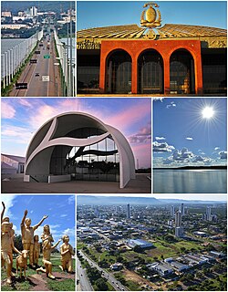
 From the top; clockwise: Tocantins River Bridge; Araguaia Palace; Tocantins River; Aerial view of Palmas; Súplica dos Pioneiros monument and Coluna Prestes Memorial. | |
| Nickname: Capital Ecológica (Ecological Capital) | |
| Motto(s): Co Yvy Ore Retama (Tupi for 'This Land is Ours'; in Portuguese: Esta Terra é Nossa) | |
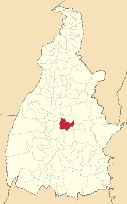
 Localization of Palmas in Tocantins | |
| Coordinates: 10°11′04″S 48°20′01″W / 10.18444°S 48.33361°W | |
| Country | |
| Region | North |
| State | |
| Founded | May 20, 1989 |
| Government | |
| • Mayor | Cinthia Ribeiro (PSDB) |
| Area | |
• Total | 2,218.93 km2 (856.73 sq mi) |
| Elevation | 230 m (755 ft) |
| Population (2020 [1]) | |
• Total | 306,296 |
| • Density | 12,924/km2 (33,470/sq mi) |
| Demonym | Palmense |
| Time zone | UTC−3 (BRT) |
| Postal Code | From 77000-001 to 77249-999 |
| Area code | +55 63 |
| HDI (2010) | 0.788 – high[2] |
| Website | www |
Palmas (Brazilian Portuguese pronunciation: [ˈpawmɐs], Palm trees; Akwẽ-Xerénte: Akwẽ krikahâzawre wam hã [akwẽ kɾikahəʐawɾɛ wam hə̃][3]) is the capital and largest city of the state of Tocantins, Brazil. According to IBGE estimates from 2020, the city had 306,296 inhabitants. Palmas has a metropolitan area with 471,639 inhabitants.
Palmas was founded in 1990 and developed from the ground up in a former agricultural area as the capital of the new state of Tocantins, formed under the 1988 constitution.[4] It was intended to develop a relatively undeveloped area of the nation to provide better jobs for people. The city has a well-designed road system, and its urban zoning is modeled on that of Brasília, the national capital. A symmetrical park lies at the city centre, and a large central avenue similar to Brasília's extends north to south.[4] The city is home to the Federal University of Tocantins.
In 2002, the Lajeado Hydroelectric Power Plant was completed on the Tocantins River, creating a large reservoir and giving the city new beaches. The project also included construction of a huge bridge: the Fernando Henrique Cardoso Bridge, 8 kilometers (5.0 mi) long, connects Palmas with the major highway BR-153 and the district of Luzimangues in Porto Nacional.
The Palmas Airport connects Palmas with many Brazilian cities.
- ^ "IBGE 2020". Retrieved 26 January 2021.
- ^ "Archived copy" (PDF). United Nations Development Programme (UNDP). Archived from the original (PDF) on July 8, 2014. Retrieved August 1, 2013.
{{cite web}}: CS1 maint: archived copy as title (link) - ^ Cotrim, Rodrigo Guimarães Prudente Marquez (2014). "Documentação da língua–cultura indígena brasileira xerente (Jê): um caso de media documentation, educação tecno–linguística e empoderamento linguístico". In Malvestitti, Marisa; Dreidemie, Patricia (eds.). III Encuentro de Lenguas Indígenas Americanas. Libro de Actas. Universidad Nacional de Río Negro. pp. 171–84. ISBN 978-987-3667-00-8.
- ^ a b Rego, Renato Leão (2020). "Palmas, the last capital city planned in twentieth-century Brazil". Urbe. Revista Brasileira de Gestão Urbana. 12. doi:10.1590/2175-3369.012.e20190168. ISSN 2175-3369.


