Back بمبة Arabic Pampa (xeobotánica) AST Пампасы Byelorussian Пампа Bulgarian পম্পাস Bengali/Bangla Pampa (kompezenn) Breton Pampa (geobotànica) Catalan پامپا CKB Pampa Czech Pampa Welsh
This article needs additional citations for verification. (December 2007) |
Pampas Plain | |
|---|---|
 Landscape in the Pampas at eye level in Brazil | |
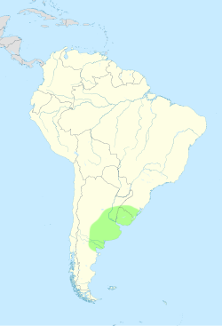
 Approximate location and borders of the Pampas encompassing the southeastern area of South America bordering the Atlantic Ocean | |
| Coordinates: 35°S 62°W / 35°S 62°W | |
| Countries | |
| Area | |
• Total | 1,200,000 km2 (500,000 sq mi) |
| Elevation | 160 m (520 ft) |
| Population | |
• Total | 44,399,835 |
| • Density | 37/km2 (96/sq mi) |
The Pampas (from the Quechua: pampa, meaning "plain"), also known as the Pampas Plain, are fertile South American low grasslands that cover more than 1,200,000 square kilometres (460,000 sq mi) and include the Argentine provinces of Buenos Aires, La Pampa, Santa Fe, Entre Ríos, and Córdoba; all of Uruguay; and Brazil's southernmost state, Rio Grande do Sul. The vast plains are a natural region, interrupted only by the low Ventana and Tandil hills, near Bahía Blanca and Tandil (Argentina), with a height of 1,300 m (4,265 ft) and 500 m (1,640 ft), respectively.
The climate is temperate, with precipitation of 600 to 1,200 mm (23.6 to 47.2 in) that is more or less evenly distributed throughout the year, making the soils appropriate for agriculture. The area is also one of the distinct physiography provinces of the larger Paraná–Paraguay plain division.
It is considered that the limit of the Pampas plain is to the north with the Atlantic Forest and the Great Chaco Plain, to the west with the Pampas Mountains and the Cuyo Region, and to the south with Patagonia.