Back جبل بانامنت Arabic جبل بانامنت ARZ Панаминт Рейндж Bulgarian Panamint Range CEB Panamint Range Czech Panamint Range German Chaînon Panamint French पैनामिंट श्रेणी Hindi パナミント山脈 Japanese Panamint Range Dutch
| Panamint Range | |
|---|---|
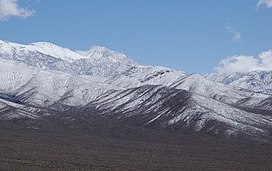
 Panamint Range looking toward Telescope Peak | |
| Highest point | |
| Peak | Telescope Peak |
| Elevation | 11,043 ft (3,366 m) NAVD 88[1] |
| Coordinates | 36°10′11″N 117°05′21″W / 36.169815947°N 117.089198336°W[1] |
| Geography | |
| Country | United States |
| State | California |
| District | Inyo County |
| Range coordinates | 36°10′11.8″N 117°5′21.2″W / 36.169944°N 117.089222°W[2] |
| Topo map | USGS Telescope Peak |
The Panamint Range is a short rugged fault-block mountain range in the northern Mojave Desert, within Death Valley National Park in Inyo County, eastern California. A small part of the southern end of the range is in San Bernardino County.[3] Dr. Darwin French is credited as applying the term Panamint in 1860 during his search for the fabled Gunsight Lode.[4]
The origin of the name is the Paiute or Koso word Panümünt or Pa (water) and nïwïnsti (person).[5][6]
- ^ a b "Telescope". NGS Data Sheet. National Geodetic Survey, National Oceanic and Atmospheric Administration, United States Department of Commerce. Retrieved 2022-09-18.
- ^ "Panamint Range". Geographic Names Information System. United States Geological Survey, United States Department of the Interior. Retrieved 2009-05-03.
- ^ https://prd-tnm.s3.amazonaws.com/StagedProducts/Maps/USTopo/PDF/CA/CA_Sourdough_Spring_20150306_TM_geo.pdf
- ^ Gudde, Erwin G. (1998). California place names : the origin and etymology of current geographical names (4th ed., rev. and enl. ed.). Berkeley: University of California Press. p. 102 & 280. ISBN 0520213165.
- ^ Gudde, Erwin G. (1998). California place names : the origin and etymology of current geographical names (4th ed., rev. and enl. ed.). Berkeley: University of California Press. p. 280. ISBN 0520213165.
- ^ Bryan, T. Scott (15 January 2015). The Explorer's Guide to Death Valley National Park. p. 22. ISBN 9781607323419.
