This article needs additional citations for verification. (February 2014) |
Pascoe Vale Road | |
|---|---|
 | |
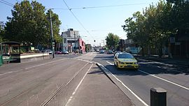
| Pascoe Vale Road in Moonee Ponds | |
| Coordinates | |
| General information | |
| Type | Road |
| Length | 14.9 km (9.3 mi)[1] |
| Gazetted | September 1960[2] |
| Route number(s) | |
| Major junctions | |
| North end | David Munroe Drive Coolaroo, Melbourne |
| |
| South end | Moonee Ponds, Melbourne |
| Location(s) | |
| Major suburbs | Meadow Heights, Dallas, Broadmeadows, Jacana, Glenroy, Oak Park, Pascoe Vale, Strathmore |
| ---- | |
Pascoe Vale Road is a major thoroughfare through the northern suburbs of Melbourne, connecting the outer northern fringe to the inner northern suburbs.
- ^ "Pascoe Vale Road" (Map). Google Maps. Retrieved 8 November 2021.
- ^ "Victorian Government Gazette". State Library of Victoria. 7 September 1960. pp. 2977–81. Retrieved 23 May 2024.

