Back نهر پاتوكسينت ARZ Patuxent River CEB Patuxent Czech Патаксент CV Patuxent River German Patuxent Finnish Patuxent French Patuxent Dutch Patuxent Polish Патаксент Russian
| Patuxent River Patuxent tributary/Patuxent affluent | |
|---|---|
 Patuxent River near Bowie | |
 Patuxent River drainage basin | |
| Location | |
| Country | United States |
| State | Maryland |
| Major cities | Columbia, Laurel, Bowie, Upper Marlboro |
| Physical characteristics | |
| Source | |
| • location | 2.3 mi (3.7 km) southwest of Mount Airy, Maryland, U.S. |
| • coordinates | 39°20′55″N 77°10′39″W / 39.34861°N 77.17750°W |
| • elevation | 823 ft (251 m) |
| Mouth | Chesapeake Bay |
• location | 2 mi (3.2 km) east of Solomons, Maryland |
• coordinates | 38°18′43″N 76°25′19″W / 38.31194°N 76.42194°W |
• elevation | 0 ft (0 m) |
| Length | 115 mi (185 km) |
| Basin size | 908 sq mi (2,350 km2) |
| Discharge | |
| • location | Laurel, Maryland |
| • average | 171 cu ft/s (4.8 m3/s) |
| • minimum | 8 cu ft/s (0.23 m3/s) |
| • maximum | 2,870 cu ft/s (81 m3/s) |
| Discharge | |
| • location | Bowie, Maryland |
| • average | 647 cu ft/s (18.3 m3/s) |
| • minimum | 134 cu ft/s (3.8 m3/s) |
| • maximum | 4,500 cu ft/s (130 m3/s) |
| Basin features | |
| Tributaries | |
| • left | Little Patuxent River |
| • right | Western Branch |

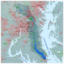
The Patuxent River is a tributary of the Chesapeake Bay in the state of Maryland. There are three main river drainages for central Maryland: the Potomac River to the west passing through Washington, D.C., the Patapsco River to the northeast passing through Baltimore, and the Patuxent River between the two. The 908-square-mile (2,352 km2) [1] Patuxent watershed had a rapidly growing population of 590,769 in 2000. It is the largest and longest river entirely within Maryland, and its watershed is the largest completely within the state.
- ^ Costanza, Robert; et al. (May 1, 2002). "Integrated Ecological Economic Modeling of the Patuxent River Watershed, Maryland". Ecological Monographs. pp. 203–231. Retrieved August 27, 2018.