Back Pays de la Loire Afrikaans Pays de la Loire ALS Países d'a Loira AN بايي دو لا لوار Arabic بايى دو لا لوار ARZ Países del Loira AST Pays de la Loire suyu Aymara Luara torpaqları Azerbaijani پی دو لا لوآر AZB Pays de la Loire BAN
Pays de la Loire
| |
|---|---|
 | |
 | |
| Coordinates: 47°25′03″N 00°51′18″W / 47.41750°N 0.85500°W | |
| Country | |
| Prefecture | Nantes |
| Departments | 5
|
| Government | |
| • President of the Regional Council | Christelle Morançais (DVD) |
| Area | |
• Total | 32,082 km2 (12,387 sq mi) |
| • Rank | 8th |
| Population (2022)[1] | |
• Total | 3,879,216 |
| • Density | 120/km2 (310/sq mi) |
| GDP | |
| • Total | €127.189 billion |
| • Per capita | €33,700 |
| Time zone | UTC+01:00 (CET) |
| • Summer (DST) | UTC+02:00 (CEST) |
| ISO 3166 code | FR-PDL |
| NUTS Region | FR5 |
| Website | www.paysdelaloire.fr |
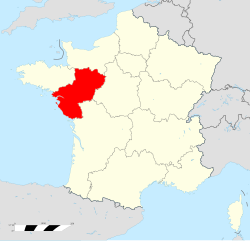
Pays de la Loire (French pronunciation: [pe.i d(ə) la lwaʁ]; lit. 'Lands of the Loire') is one of the eighteen regions of France, located on the country's Atlantic coast. It was created in the 1950s to serve as a zone of influence for its capital and most populated city, Nantes, one of a handful of French "balancing metropolises" (métropoles d'équilibre).[a] In 2020, Pays de la Loire had a population of 3,832,120.
- ^ "Populations de référence 2022" (in French). The National Institute of Statistics and Economic Studies. 19 December 2024.
- ^ "EU regions by GDP, Eurostat". Retrieved 18 September 2023.
Cite error: There are <ref group=lower-alpha> tags or {{efn}} templates on this page, but the references will not show without a {{reflist|group=lower-alpha}} template or {{notelist}} template (see the help page).
