Back مقاطعة بينيلاس (فلوريدا) Arabic Pinellas County, Florida BAR Пинелас (окръг, Флорида) Bulgarian পিন্নেলাস কাউন্টি, ফ্লোরিডা BPY Pinellas Gông (Florida) CDO Пинелас (гуо, Флорида) CE Pinellas County CEB Pinellas County Czech Pinellas County, Florida Welsh Pinellas County German
Pinellas County | |
|---|---|
 | |
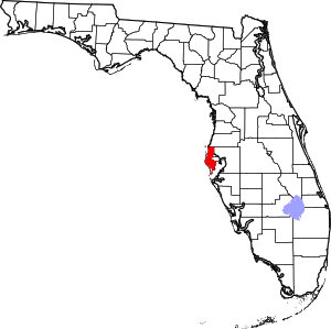
 Location within the U.S. state of Florida | |
 Florida's location within the U.S. | |
| Coordinates: 27°54′N 82°44′W / 27.90°N 82.74°W | |
| Country | |
| State | |
| Founded | January 1, 1912 |
| Named for | Spanish Punta Piñal ("Point of Pines") |
| Seat | Clearwater |
| Largest city | St. Petersburg |
| Area | |
• Total | 608 sq mi (1,570 km2) |
| • Land | 274 sq mi (710 km2) |
| • Water | 334 sq mi (870 km2) 55.0% |
| Population (2020) | |
• Total | 959,107 |
• Estimate (2023) | |
| • Density | 3,491/sq mi (1,348/km2) |
| Time zone | UTC−5 (Eastern) |
| • Summer (DST) | UTC−4 (EDT) |
| Congressional districts | 13th, 14th |
| Website | www |
Pinellas County (US: /pɪˈnɛləs/, pih-NEL-əss) is located on the west central coast of the U.S. state of Florida.[2] As of the 2020 census, the population was 959,107, making it the seventh-most populous county in the state.[3] It is also the most densely populated county in Florida, with 3,491 residents per square mile. The county is part of the Tampa–St. Petersburg–Clearwater Metropolitan Statistical Area.[2] Clearwater is the county seat.[4] St. Petersburg is the largest city in the county, as well as the largest city in Florida that is not a county seat.[2]
- ^ "U.S. Census Bureau QuickFacts: Pinellas County, Florida". Census.gov. Retrieved July 20, 2022.
- ^ a b c Kunerth, Jeff (June 5, 2014). "Orlando moves past St. Petersburg to become Florida's fourth largest city". Orlando Sentinel.
- ^ "Census.gov Quick Facts Pinellas County, Florida". Retrieved March 5, 2022.
- ^ "Find a County". National Association of Counties. Archived from the original on May 31, 2011. Retrieved June 7, 2011.
