This article needs additional citations for verification. (March 2013) |
| Point Dume State Beach | |
|---|---|
 | |
| Location | Malibu, California |
| Nearest city | Malibu, California |
| Coordinates | 34°0′3.14″N 118°48′24.62″W / 34.0008722°N 118.8068389°W |
| Governing body | California Department of Parks and Recreation |
| Reference no. | 965[1] |
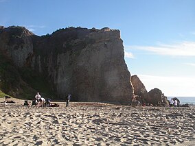
Point Dume is a promontory on the coast of Malibu, California that juts out into the Pacific Ocean. The point, a long bluff, forms the northern end of the Santa Monica Bay. Point Dume Natural Area affords a vista of the Palos Verdes Peninsula and Santa Catalina Island. Zuma Beach lies to its immediate northwest.

- ^ "Point Dume". Office of Historic Preservation, California State Parks. Retrieved October 8, 2012.


