Back مقاطعة بولك (فلوريدا) Arabic Polk County, Florida BAR Полк (окръг, Флорида) Bulgarian পোল্ক কাউন্টি, ফ্লোরিডা BPY Polk Gông (Florida) CDO Полк (гуо, Флорида) CE Polk County (kondado sa Tinipong Bansa, Florida) CEB Polk County, Florida Welsh Polk County (Florida) German Κομητεία Πολκ (Φλόριντα) Greek
Polk County | |
|---|---|
 Polk County courthouse in Bartow | |
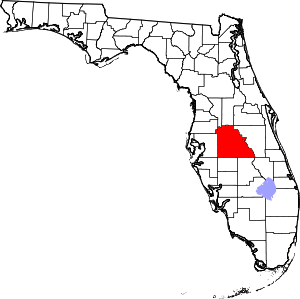
 Location within the U.S. state of Florida | |
 Florida's location within the U.S. | |
| Coordinates: 27°58′N 81°42′W / 27.96°N 81.7°W | |
| Country | |
| State | |
| Founded | February 8, 1861 |
| Named for | James K. Polk |
| Seat | Bartow |
| Largest city | Lakeland |
| Area | |
• Total | 2,011 sq mi (5,210 km2) |
| • Land | 1,798 sq mi (4,660 km2) |
| • Water | 213 sq mi (550 km2) 10.6% |
| Population (2020) | |
• Total | 725,046 |
• Estimate (2023) | 818,330 |
| • Density | 360/sq mi (140/km2) |
| Time zone | UTC−5 (Eastern) |
| • Summer (DST) | UTC−4 (EDT) |
| Area code | 863 |
| Congressional districts | 11th, 15th, 18th |
| Website | www |
Polk County (/poʊk/) is a county located in the central portion of the U.S. state of Florida. The county population was 725,046, as of the 2020 census, and estimated to be 818,330, as of July 1, 2023.[1] Its county seat is Bartow,[2] and its largest city is Lakeland. Polk County comprises the Lakeland–Winter Haven metropolitan statistical area (MSA).[3] This MSA is the 77th-most populous one and the 89th-most populous primary statistical area of the United States as of July 1, 2012.[4][5] The center of population of Florida is located in Polk County, near the city of Lake Wales.[6] Polk County is home to one public university, one state college, and four private universities.
- ^ "QuickFacts Polk County, Florida". United States Census Bureau. Retrieved March 25, 2024.
- ^ "Find a County". National Association of Counties. Retrieved June 7, 2011.
- ^ "Revised Delineations of Metropolitan Statistical Areas, Micropolitan Statistical Areas, and Guidance on the Uses of the Delineations of These Areas" (PDF). Executive Office of the President. July 21, 2023. p. 59. Retrieved July 21, 2023.
- ^ "Table 1. Annual Estimates of the Population of Metropolitan and Micropolitan Statistical Areas: April 1, 2010 to July 1, 2012". 2012 Population Estimates. United States Census Bureau, Population Division. March 2013. Archived from the original (CSV) on April 1, 2013. Retrieved March 20, 2013.
- ^ "Table 2. Annual Estimates of the Population of Combined Statistical Areas: April 1, 2010 to July 1, 2012". 2012 Population Estimates. United States Census Bureau, Population Division. March 2013. Archived from the original (CSV) on May 17, 2013. Retrieved March 20, 2013.
- ^ "Centers of Population by State: 2010". United States Census Bureau. Retrieved June 16, 2014.


