Back بورت كولبورن (أونتاريو) Arabic Port Colborne ATJ Порт-Колбарн Byelorussian Port Colborne CEB Port Colborne German Port Colborne, Ontario DIQ Port Colborne Spanish پورت کولبورن Persian Port Colborne French ポートコルボーン Japanese
Port Colborne | |
|---|---|
| City of Port Colborne | |
![Former bank building on West Street in Port Colborne[1]](http://upload.wikimedia.org/wikipedia/commons/thumb/a/a7/PortColborneBank.jpg/250px-PortColborneBank.jpg) Former bank building on West Street in Port Colborne[1] | |
| Motto: "Gateway to Navigation"[2] | |
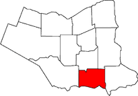
 Location of Port Colborne in the Niagara Region | |
| Coordinates: 42°53′N 79°15′W / 42.883°N 79.250°W | |
| Country | Canada |
| Province | Ontario |
| Region | Niagara |
| Settled | 1830s |
| Incorporated | 1870 (village) |
| 1966 (city) | |
| Government | |
| • Mayor | William Steele |
| • MP | Vance Badawey (Liberal) |
| • MPP | Jeff Burch (NDP) |
| Area | |
| • Land | 121.96 km2 (47.09 sq mi) |
| Elevation | 175.30 m (575.13 ft) |
| Population (2021)[4] | |
• Total | 20,033 |
| • Density | 164.2/km2 (425/sq mi) |
| Demonym | Port Colbornite |
| Time zone | UTC-5 (EST) |
| • Summer (DST) | UTC-4 (EDT) |
| Forward Sortation Area | |
| Area code(s) | 905, 289, 365, and 742 |
| GNBC Code | FCHYP[6] |
| Website | portcolborne |
Port Colborne is a city in Ontario, Canada that is located on Lake Erie, at the southern end of the Welland Canal, in the Niagara Region of Southern Ontario. The original settlement, known as Gravelly Bay, dates from 1832 [7] and was renamed after Sir John Colborne, a British war hero and the Lieutenant Governor of Upper Canada at the time of the opening of the (new) southern terminus of the First Welland Canal in 1833. The city's population in 2021 was 20,033.
- ^ "index.HTM". Archived from the original on July 13, 2011. Retrieved July 31, 2017.
- ^ "City of Port Colborne - Quick Facts". portcolborne.ca. Archived from the original on July 15, 2017. Retrieved July 31, 2017.
- ^ City of Port Colborne • Mayor's Office
- ^ a b "Port Colborne, Ontario (Code 3526011) census profile". 2021 Census of Population. Statistics Canada. Retrieved October 23, 2022.
- ^ Cite error: The named reference
CCNwas invoked but never defined (see the help page). - ^ "Port Colborne". Natural Resources Canada. October 6, 2016.
- ^ "Port Colborne - Ontario, Canada". Retrieved July 31, 2017.

