This article needs additional citations for verification. (December 2020) |
Port Area
Port District South Port District | |
|---|---|
District of Manila | |
 Manila South Harbor with the Bureau of Customs building in the center | |
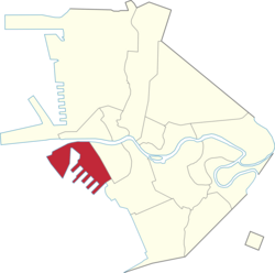
 Map of Manila showing the location of Port Area | |
 | |
| Coordinates: 14°35′19″N 120°58′07″E / 14.588726°N 120.968597°E | |
| Country | Philippines |
| Region | National Capital Region |
| City | Manila |
| District | Part of the 5th district of Manila |
| Barangays | 5 |
| Area | |
• Total | 3.1528 km2 (1.2173 sq mi) |
| Population (2020)[1] | |
• Total | 72,605 |
| • Density | 23,000/km2 (60,000/sq mi) |
| Time zone | UTC+08:00 (Philippine Standard Time) |
| ZIP code | 1018 (Port Area South) |
| Area code | 2 |
Port Area, Manila, also known as both the Manila Port District and South Port District,[2][3] is a district of the city of Manila, Philippines. It is entirely a reclaimed land occupied by Manila's South Harbor and Baseco Compound (Engineer's Island). It is bounded on the north by the Pasig River, facing the districts of Tondo and San Nicolas, on the west by the Manila Bay, on the east by Intramuros, separated by Radial Road 1, and on the south by the district of Ermita. Post-war developments at the Manila South Harbor eventually paved the way for the migration of natives from the different provinces, making it one of the largest ghettos in the Philippines.
- ^ "2020 Census of Population and Housing Results" (PDF). Philippine Statistics Authority. August 16, 2021. Retrieved May 31, 2023.
- ^ Bach, John (1920). City of Manila, Philippine Islands (Map). 1:11,000. Bureau of Commerce and Industry. Retrieved May 31, 2023.
- ^ De Jesus, Domingo (1958). Table and Pocket Map Guide City of Manila Republic of the Philippines (Map). 1:24,268. Retrieved May 31, 2023.
