Back ميناء غزة Arabic Puerto de Gaza Spanish Gazako portua Basque Port de Gaza French נמל עזה HE غزہ کی بندرگاہ Urdu 加沙港 Chinese
| Port of Gaza | |
|---|---|
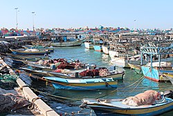
 Gaza port, 2015 | |
 Click on the map for a fullscreen view | |
| Location | |
| Country | State of Palestine |
| Location | Gaza Governorate, Gaza Strip |
| Coordinates | 31°31′33″N 34°25′50″E / 31.52583°N 34.43056°E |
| Grid position | 096/104 PAL |
| UN/LOCODE | PSGZA[1] |
| Details | |
| Operated by | Palestinian National Authority |
| Land area | 48,000 m2 (520,000 sq ft) |
| No. of piers | 970 and 330 m (3,180 and 1,080 ft) |
The Port of Gaza is a small port near the Rimal district of Gaza City, Gaza.[2] It is the home port of Palestinian fishing-boats and the base of the Palestinian Naval Police, a branch of the Palestinian National Security Forces. Under the Oslo II Accord, the activities of the Palestinian Naval Police are restricted to 6 nautical miles from the coast.[3] Since 2007, the Port of Gaza has been under an Israeli-imposed naval blockade as part of a blockade of the Gaza Strip, and activities at the port have been restricted to small-scale fishing.

- ^ "UNLOCODE (PS) - PALESTINE, STATE OF". service.unece.org. Retrieved 25 April 2020.
- ^ Doughty and El Aydi, 1995, p. 13
- ^ Karsh, Efraim (2013). Israel: the First Hundred Years: Volume II: From War to Peace?. p. 216.