| Main page | Maps |
The Maps and Cartography Portal
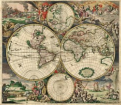
A map is a symbolic depiction of interrelationships, commonly spatial, between things within a space. A map may be annotated with text and graphics. Like any graphic, a map may be fixed to paper or other durable media, or may be displayed on a transitory medium such as a computer screen. Some maps change interactively. Although maps are commonly used to depict geographic elements, they may represent any space, real or fictional. The subject being mapped may be two-dimensional such as Earth's surface, three-dimensional such as Earth's interior, or from an abstract space of any dimension.
Maps of geographic territory have a very long tradition and have existed from ancient times. The word "map" comes from the medieval Latin: Mappa mundi, wherein mappa meant 'napkin' or 'cloth' and mundi 'of the world'. Thus, "map" became a shortened term referring to a flat representation of Earth's surface. (Full article...)
Cartography (/kɑːrˈtɒɡrəfi/; from Ancient Greek: χάρτης chartēs, 'papyrus, sheet of paper, map'; and γράφειν graphein, 'write') is the study and practice of making and using maps. Combining science, aesthetics and technique, cartography builds on the premise that reality (or an imagined reality) can be modeled in ways that communicate spatial information effectively. (Full article...)
Selected article -
The map of Juan de la Cosa is a world map that includes the earliest known representation of the New World and the first depiction of the equator and the Tropic of Cancer on a nautical chart. The map is attributed to the Castilian navigator and cartographer Juan de la Cosa and was likely created in 1500. (Full article...)
General images -
Selected quote
| “ | We all inherit a great deal of useless knowledge, and a great deal of misinformation and error (maps that were formerly thought to be accurate), so that there is always a portion of what we have been told that must be discarded. | ” |
| — S. I. Hayakawa | ||
Related portals
Related WikiProjects
Selected biography -
Amerigo Vespucci (/vɛˈspuːtʃi/ vesp-OO-chee, Italian: [ameˈriːɡo veˈsputtʃi]; 9 March 1454 – 22 February 1512) was an Italian explorer and navigator from the Republic of Florence for whom "America" is named.
Vespucci participated in at least two voyages of the Age of Discovery between 1497 and 1504, first on behalf of Spain (1499–1500) and then for Portugal (1501–1502). In 1503 and 1505, two booklets were published under his name containing colourful descriptions of these explorations and other voyages. Both publications were extremely popular and widely read throughout much of Europe. Historians still dispute the authorship and veracity of these accounts, but they were instrumental in raising awareness of the discoveries and enhancing the reputation of Vespucci as an explorer and navigator. (Full article...)
Selected picture

Did you know
- ... that Kathryn Maple won the Sunday Times Watercolour Competition twice in three years?
- ... that the actress Lottie Williams was one of the cakewalk dancers depicted on the front cover of the sheet music for Scott Joplin's "Maple Leaf Rag"?
- ... that the Canadian League for Peace and Democracy organized a 10,000-person rally at Maple Leaf Gardens in Toronto to protest a 2,500-person fascist rally?
- ... that the 100 gecs tree was listed as a "place of worship" on Google Maps?
- ... that actress Agnes Mapes had to improvise a complex choreographed dance from basic poses for the 1907 play The Holy City?
- ... that DeepStateMap.Live, an interactive map of the Russian invasion of Ukraine, received up to 120,000 visitors in 30 minutes during the Battle of Izium in the 2022 Kharkiv counteroffensive?
Topics
Map - Atlas - Geography - Topography
Cartography: Cartographers - History of cartography - Ancient world maps - World maps - Compass rose - Generalization - Geographic coordinate system - Geovisualization - Relief depiction - Scale - Terra incognita - Planetary cartography
Map projection: Azimuthal equidistant - "Butterfly" - Dymaxion - Gall–Peters - General Perspective - Goode homolosine - Mercator - Mollweide - Orthographic - Peirce quincuncial - Robinson - Sinusoidal - Stereographic
Maps: Animated mapping - Cartogram - Choropleth map - Estate map - Geologic map - Linguistic map - Nautical chart - Pictorial map - Reversed map - Road atlas - Thematic map - Topographic map - Weather map - Web mapping - World map
Map examples
World

Historical
Thematic
Geographic
Political
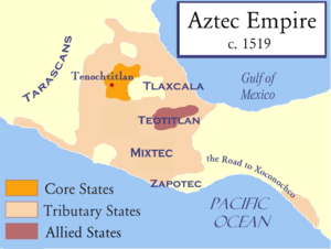
Nautical

Categories
Things you can do
|
Here are some Geography related tasks you can do:
|
Atlases and maps of the world at Wikimedia Commons
Associated Wikimedia
The following Wikimedia Foundation sister projects provide more on this subject:
-
Commons
Free media repository -
Wikibooks
Free textbooks and manuals -
Wikidata
Free knowledge base -
Wikinews
Free-content news -
Wikiquote
Collection of quotations -
Wikisource
Free-content library -
Wikiversity
Free learning tools -
Wiktionary
Dictionary and thesaurus


