Back Provincia de Uelba AN ولبة (مقاطعة) Arabic اويلبا (مقاطعه) ARZ Provincia de Huelva AST اوئلوا اوستانی AZB Уэльва (правінцыя) Byelorussian Proviñs Huelva Breton Província de Huelva Catalan Provincia de Huelva CEB Provincie Huelva Czech
Huelva | |
|---|---|
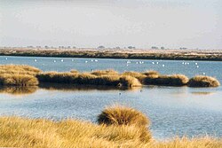
 A wetland area of Doñana National Park | |
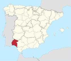
 Map of Spain with Huelva highlighted | |
| Coordinates: 37°33′N 6°55′W / 37.550°N 6.917°W | |
| Country | Spain |
| Autonomous community | |
| Capital | Huelva |
| Government | |
| • Body | Provincial Deputation of Huelva |
| • President | Ignacio Caraballo (PSOE) |
| Area | |
• Total | 10,148 km2 (3,918 sq mi) |
| • Rank | Ranked 25th |
| Population (2013) | |
• Total | 483,792 |
| • Rank | Ranked 31st |
| • Density | 48/km2 (120/sq mi) |
| Parliament | Cortes Generales |

Huelva (Spanish pronunciation: [ˈwelβa] ⓘ) is a province of southern Spain, in the western part of the autonomous community of Andalusia. It is bordered by Portugal, the provinces of Badajoz, Seville, and Cádiz, and the Atlantic Ocean. Its capital is Huelva.
Its area is 10,148 km². Its population is 483,792 (2005), of whom about 30% live in the capital, and its population density is 47.67/km². It contains 79 municipalities.
The economy is based on agriculture and mining. The famous Rio Tinto mines have been worked since before 1000 BC, and were the major source of copper for the Roman Empire. As an indication of the scope of ancient mining, sixteen million tons of Roman slag have been identified at the Roman mines. British companies resumed large-scale mining in 1873; the district is the namesake of the Rio Tinto Group.[1]
In the 21st century, municipalities such as Moguer, Palos de la Frontera, and Lepe, have witnessed the development of intensive water-demanding strawberry farming, which has elicited attention on the basis of alleged mispractices and abuses regarding the labor conditions of foreign workers and the ecocidal depletion of water resources in Doñana.
The province contains Palos de la Frontera, and Moguer, where Christopher Columbus sailed out of on his first voyage in 1492, and shares the Parque Nacional de Doñana, located mainly in Almonte.

