Back محافظة بويرتو بلاتا Arabic Puerto Plata (província) Catalan Provincia de Puerto Plata CEB Puerto Plata (Provinz) German Πουέρτο Πλάτα Greek Provincia de Puerto Plata Spanish Puerto Plata probintzia Basque استان پوئرتو پلاتا Persian Puerto Plata Finnish Puerto Plata (province) French
Puerto Plata | |
|---|---|
| Motto(s): La Tacita de Plata La novia del Atlantico | |
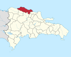
 Location of the Puerto Plata Province | |
| Coordinates: 19°44′12″N 70°46′12″W / 19.73667°N 70.77000°W | |
| Country | |
| Province since | 1850 |
| Capital | San Felipe de Puerto Plata |
| Government | |
| • Type | Subdivisions |
| • Body | 9 municipalities 12 municipal districts |
| • Congresspersons | 1 Senator 6 Deputies |
| Area | |
• Total | 1,852.90 km2 (715.41 sq mi) |
| Population (2014) | |
• Total | 470,839 |
| • Density | 250/km2 (660/sq mi) |
| Time zone | UTC-4 (AST) |
| Area code | 1-809 1-829 1-849 |
| ISO 3166-2 | DO-18 |
| Postal Code | 57000 |

Puerto Plata (Spanish pronunciation: [pweɾtoˈplata], Silver Port); (French: Port-de-Plate)[1] is a province in northern Dominican Republic. It is divided into 9 municipalities, 12 municipal districts and its capital is the resort city of the same name. Neighboring provinces clockwise: Monte Cristi to the southwest, Valverde and Santiago to the south and Espailat to the east, along with the Septentrional mountain range to the north (which separates it from Laguna Salada), and has a coastline with the Atlantic Ocean. The area has become an increasingly popular tourist attraction since the late 1990s mainly due to its fine beaches.
Created from the Santiago Province in 1867 as a "maritime district", it became a province in 1907, when maritime districts were suppressed by a new Dominican constitution.
- ^ Médéric Louis Élie Moreau de Saint-Méry (1796). "A Topographical and Political Description of the Spanish Part of Saint-Domingo; Containing, General Observations on the Climate, Population and Productions; on the Character and Manners of the Inhabitants; with an Account of the Several Branches of the Government, Volume 1". British Library. p. 38. Retrieved 25 May 2024.

