Back منطقة بوري Arabic بورى ARZ पुरी जिला Bihari পুরী জেলা Bengali/Bangla Districte de Puri Catalan Puri (distrito) CEB Puri (Distrikt) German Distrito de Puri Spanish Puri barrutia Basque بخش پوری Persian
This article needs additional citations for verification. (September 2022) |
Puri district | |
|---|---|
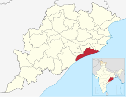
 Location in Odisha | |
| Coordinates: 19°48′58″N 85°49′59″E / 19.816°N 85.833°E | |
| Country | |
| State | |
| Headquarters | Puri |
| Government | |
| • Collector & District Magistrate | Siddhartha Sankara Swain, IAS |
| • Superintendent of Police | Pinaka Misra, IPS |
| Area | |
• Total | 3,479 km2 (1,343 sq mi) |
| Population (2011)[1] | |
• Total | 1,698,730 |
| • Density | 490/km2 (1,300/sq mi) |
| Languages | |
| • Official | Odia, English |
| Time zone | UTC+5:30 (IST) |
| PIN | 752 xxx |
| Vehicle registration | OD-13 |
| Coastline | 150.4 kilometres (93.5 mi) |
| Nearest city | Bhubaneswar |
| Sex ratio | 1.032 ♂/♀ |
| Literacy | 85.37% |
| Lok Sabha constituency | Puri, Jagatsinghpur |
| Vidhan Sabha constituency | 6
|
| Climate | Aw (Köppen) |
| Avg. summer temperature | 37 °C (99 °F) |
| Avg. winter temperature | 13.9 °C (57.0 °F) |
| Website | www |
| This article is part of a series on |
| Odisha |
|---|
 |
| Governance |
| Topics |
|
Districts Divisions |
| GI Products |
|
|
Puri district is a coastal district of the Odisha state of India. It has one sub-division, 11 tahasils and 11 blocks and comprises 1722 revenue villages. Puri is the only municipality of the district. Konark, Nimapada, Pipili, Satyabadi and Kakatpur are the NACs in this district and Brahmagiri is a semi-urban town.


