Back مقاطعة بوتنام (إنديانا) Arabic Putnam County, Indiana BAR Путнам (окръг, Индиана) Bulgarian পুতনাম কাউন্টি, ইন্ডিয়ানা BPY Putnam Gông (Indiana) CDO Патнам (гуо, Индиана) CE Putnam County (kondado sa Tinipong Bansa, Indiana) CEB Putnam County, Indiana Welsh Putnam County (Indiana) German Κομητεία Πάτναμ (Ιντιάνα) Greek
Putnam County | |
|---|---|
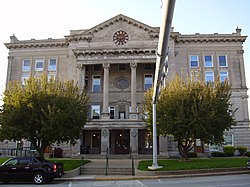
 Putnam County Courthouse in Greencastle | |
 Location within the U.S. state of Indiana | |
 Indiana's location within the U.S. | |
| Coordinates: 39°40′N 86°50′W / 39.67°N 86.84°W | |
| Country | |
| State | |
| Founded | December 31, 1821 (created) April 1822 (organized)[1] |
| Named for | Israel Putnam |
| Seat | Greencastle |
| Largest city | Greencastle |
| Area | |
• Total | 482.69 sq mi (1,250.2 km2) |
| • Land | 480.53 sq mi (1,244.6 km2) |
| • Water | 2.16 sq mi (5.6 km2) 0.45% |
| Population (2020) | |
• Total | 36,726 |
| • Density | 76/sq mi (29/km2) |
| Time zone | UTC−5 (Eastern) |
| • Summer (DST) | UTC−4 (EDT) |
| Congressional district | 4th |
| Website | co |
| Indiana county number 67 | |
Putnam County is a county located in the U.S. state of Indiana. As of the 2020 United States Census, the population was 36,726.[2] The county seat is Greencastle.[3] The county was named for Israel Putnam, a hero in the French and Indian War and a general in the American Revolutionary War. The county was created in 1821 and organized in April 1822.[4]
- ^ Cite error: The named reference
historywas invoked but never defined (see the help page). - ^ "Quickfacts: Putnam County, Indiana". United States Census Bureau. Retrieved June 6, 2023.
- ^ "Find a County". National Association of Counties. Retrieved June 7, 2011.
- ^ Peggy Tuck Sinko: Indiana Atlas of Historical County Boundaries, John H. Long, Ed., Charles Scribner's Sons, Simon & Schuster Macmillan, New York, N.Y., 1996, p. 245.