Back Río Putumayo Afrikaans نهر بوتومايو Arabic Ríu Putumayo AST Putumayo Azerbaijani پوتوماجو چایی AZB Путумаё Byelorussian Путумайо (река) Bulgarian পুতুমাইয়ো নদী Bengali/Bangla Stêr Putumayo Breton Riu Putumayo Catalan
| Putumayo River Río Içá | |
|---|---|
 Putumayo at Puerto Asis, Colombia | |
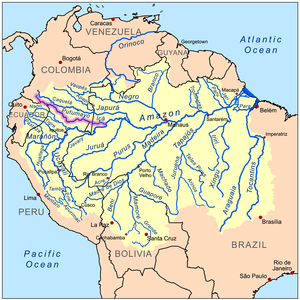
 Map of the Amazon Basin with the Putumayo River highlighted in pink | |
| Location | |
| Countries | |
| Physical characteristics | |
| Source | Andes Mountains |
| • location | East of Pasto, Colombia |
| • coordinates | 1°07′23″N 77°03′22″W / 1.123°N 77.056°W |
| • elevation | 3,000 m (9,800 ft) |
| Mouth | Amazon River |
• location | Santo Antônio do Içá, Brazil |
• coordinates | 3°8′6″S 67°58′27″W / 3.13500°S 67.97417°W |
• elevation | 47 m (154 ft) |
| Length | 1,813 km (1,127 mi) to 2,004.6 km (1,245.6 mi)[1] |
| Basin size | 120,545 km2 (46,543 sq mi)[2] |
| Discharge | |
| • location | Santo Antônio do Içá (near mouth), Amazonas state, Brazil |
| • average | (Period: 1979–2015)8,519.9 m3/s (300,880 cu ft/s)[2] (Period: 1973–1990)8,760 m3/s (309,000 cu ft/s)[3] |
| Discharge | |
| • location | Tarapaca, Colombia (320 km upstream of mouth; Basin size: 108,362 km2 (41,839 sq mi) |
| • average | (Period: 1991–2020)7,588 m3/s (268,000 cu ft/s)[5] (Period: 1979–1993)7,034.6 m3/s (248,420 cu ft/s)[4] |
| • minimum | 2,054 m3/s (72,500 cu ft/s)[4] |
| • maximum | 12,522 m3/s (442,200 cu ft/s)[4] |
| Discharge | |
| • location | Puerto Leguízamo, Colombia (1,578 km upstream of mouth; Basin size: 20,616 km2 (7,960 sq mi) |
| • average | (Period: 1988–2011)1,859 m3/s (65,600 cu ft/s)[6] |
| Discharge | |
| • location | Puerto Asís, Colombia (1,890 km upstream of mouth; Basin size: 6,410 km2 (2,470 sq mi) |
| • average | (Period: 1988–2011)821 m3/s (29,000 cu ft/s)[6] |
| Discharge | |
| • location | Puente Texas, Colombia (Basin size: 3,544 km2 (1,368 sq mi) |
| • average | (Period: 1988– 2011)496 m3/s (17,500 cu ft/s)[6] |
| • minimum | 138 m3/s (4,900 cu ft/s)[7] |
| • maximum | 2,705 m3/s (95,500 cu ft/s)[7] |
| Basin features | |
| Progression | Amazon → Atlantic Ocean |
| River system | Solimões |
| Tributaries | |
| • left | Juanambu, Caucayá, Penella, Cara Paraná, Igara Paraná, Quebrada Mutún, Pupuña, Alegría, Igarapé Cauíra |
| • right | San Juan, Orito, Guamués, Cohembi, San Miguel, Güeppi, Campuya, Ere, Algodón, Yaguas, Cotuhé, Puretê, Paraná de Jacurapa |
The Putumayo River or Içá River (Spanish: Río Putumayo, Portuguese: Rio Içá) is one of the tributaries of the Amazon River, southwest of and parallel to the Japurá River.[8][9]
- ^ Perú: Anuario de Estadistícas Ambientales 2022 (PDF). 2022.
- ^ a b "Archived copy" (PDF). meioambiente.am.gov.br. Archived from the original (PDF) on 2021-05-06. Retrieved 2021-10-03.
{{cite web}}: CS1 maint: archived copy as title (link) - ^ Théry, Hervé; Maurence, Pascale (1997). HYDROLOGIE DU BASSIN AMAZONIEN (PDF). ISBN 2-7011-1532-9.
- ^ a b c "Amazon Basin-Station: São Paulo de Olivença".
- ^ ESTUDIO NACIONAL DEL AGUA 2022 (PDF). 2023. ISBN 978-958-5489-12-7.
- ^ a b c ESTUDIOS DE FASE II PARA LA NAVEGABILIDAD DEL RÍO PUTUMAYO (PEÑASORÁ – PTO. ASÍS – PTO. LEGUÍZAMO – PTO. ALEGRÍA). 2016.
- ^ a b "3.2 Recursos hídricos".
- ^ Cite error: The named reference
faowas invoked but never defined (see the help page). - ^ Cite error: The named reference
twas invoked but never defined (see the help page).