Back Qinglong Manzu Zizhixian CEB Qinglong (Qinhuangdao) German Xian autonome mandchou de Qinglong French Contea autonoma manciù di Qinglong Italian 青竜満族自治県 Japanese 칭룽 만족 자치현 Korean Qinglong (Qinhuangdao) NB Цинлун-Маньчжурский автономный уезд Russian Qinglong, Qinhuangdao Swedish Цінлун-Маньчжурський автономний повіт Ukrainian
Qinglong County
青龙县 ᠨᡳᠣᠸᠠᠩᡤᡳᠶᠠᠨ ᡥᡳᠶᠠᠨ | |
|---|---|
青龙满族自治县 • ᠨᡳᠣᠸᠠᠩᡤᡳᠶᠠᠨ ᠮᡠᡩᡠᡵᡳ ᠮᠠᠨᠵᡠ ᡠᡴᠰᡠᡵᠠ ᡯᡳᡷᠶ ᡥᡳᠶᠠᠨ Qinglong Manchu Autonomous County | |
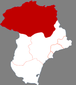
 Qinglong in Qinhuangdao | |
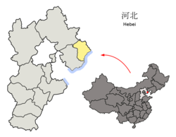
 Qinhuangdao in Hebei | |
| Coordinates: 40°24′27″N 118°56′59″E / 40.4076°N 118.9497°E | |
| Country | China |
| Province | Hebei |
| Prefecture-level city | Qinhuangdao |
| County seat | Duyanglu Subdistrict |
| Area | |
• Total | 3,309 km2 (1,278 sq mi) |
| Elevation | 239 m (784 ft) |
| Population (2020 census)[1] | |
• Total | 431,138 |
| • Density | 130/km2 (340/sq mi) |
| Time zone | UTC+8 (China Standard) |
| Postal code | 066500 |
| Area code | +86 335 |
| Website | www |
| Qinglong Manchu Autonomous County | |||||||
|---|---|---|---|---|---|---|---|
| Chinese name | |||||||
| Simplified Chinese | 青龙满族自治县 | ||||||
| Traditional Chinese | 青龍滿族自治縣 | ||||||
| Literal meaning | Blue (or teal) Dragon Man-ethnicity Autonomous County | ||||||
| |||||||
| Manchu name | |||||||
| Manchu script | ᠨᡳᠣᠸᠠᠩᡤᡳᠶᠠᠨ ᠮᡠᡩᡠᡵᡳ ᠮᠠᠨᠵᡠ ᡠᡴᠰᡠᡵᠠ ᡯᡳᡷᠶ ᡥᡳᠶᠠᠨ | ||||||
| Möllendorff | niowanggiyan muduri manju uksura dzijy hiyan | ||||||
Qinglong Manchu Autonomous County (Chinese: 青龙满族自治县, Manchu: ᠨᡳᠣᠸᠠᠩᡤᡳᠶᠠᠨ ᠮᡠᡩᡠᡵᡳ ᠮᠠᠨᠵᡠ ᡠᡴᠰᡠᡵᠠ ᡯᡳᡷᠶ ᡥᡳᠶᠠᠨ) is a Manchu autonomous county in northeastern Hebei province, China, bordering Liaoning Province to the north and east and located in the eastern part of the Yan Mountains. It is under the administration of the prefecture-level city of Qinhuangdao, and, as of 2004[update], had a population of 520,000 residing in an area of 3,309 km2 (1,278 sq mi). Bordering county-level divisions are: Lingyuan and Jianchang County (Liaoning) to the north, Liaoning's Suizhong County and Qinhuangdao city proper to the east, Qian'an and Lulong County to the south, and Kuancheng Manchu Autonomous County and Qianxi County to the west.
During the 1976 Tangshan earthquake 180,000 buildings in Qinglong collapsed, but no fatalities occurred.[2]
- ^ "权威发布!秦皇岛人口最新统计数据来了!" (in Chinese). The Paper. 2021-06-24.
- ^ Col, Jeanne-Marie (2016-11-05). "Successful Earthquake Mitigation in Qinglong County during the Great Tangshan Earthquake: Lessons for Hurricane Katrina in the United States". Chinese Public Administration Review. 4 (1/2): 9. doi:10.22140/cpar.v4i1/2.70. ISSN 1539-6754.