Back QuikSCAT German QuikSCAT Spanish QuikSCAT Finnish QuikSCAT French QuikScat Galician QuikSCAT ID QuikSCAT Italian QuikSCAT Japanese QuikSCAT Portuguese QuikSCAT SIMPLE
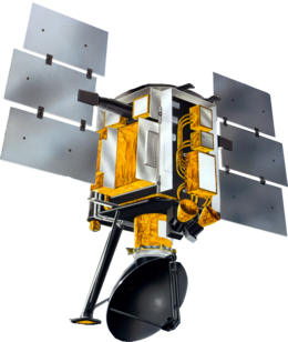
 Artist conception of QuikSCAT | |
| Mission type | Earth observation |
|---|---|
| Operator | NASA / JPL |
| COSPAR ID | 1999-034A |
| SATCAT no. | 25789 |
| Website | winds |
| Mission duration | 10 years, 4 months (achieved) 25 years, 7 months, 9 days (in orbit) |
| Spacecraft properties | |
| Manufacturer | Ball Aerospace |
| Launch mass | 970 kilograms (2,140 lb) |
| Power | 874 watts |
| Start of mission | |
| Launch date | 19 June 1999, 02:15:00 UTC |
| Rocket | Titan II(23)G |
| Launch site | Vandenberg SLC-4W |
| End of mission | |
| Deactivated | November 23,2009 |
| Orbital parameters | |
| Reference system | Geocentric |
| Regime | Sun-synchronous |
| Semi-major axis | 7,180.8 kilometers (4,461.9 mi) |
| Eccentricity | 0.0001431 |
| Perigee altitude | 807.9 kilometres (502.0 mi) |
| Apogee altitude | 809.8 kilometres (503.2 mi) |
| Inclination | 98.6175 degrees |
| Period | 100.93 minutes |
| RAAN | 101.8215 degrees |
| Argument of perigee | 71.6425 degrees |
| Mean anomaly | 308.4160 degrees |
| Mean motion | 14.27019630 |
| Repeat interval | ≈4 days (57 orbits) |
| Epoch | 30 September 2013, 12:15:56 UTC |
| Revolution no. | 74382 |
| Main Scatterometer | |
| Name | SeaWinds |
| Resolution | Nominal 25 km Standard (5 and 12.5 km special[clarification needed]) |
The NASA QuikSCAT (Quick Scatterometer) was an Earth observation satellite carrying the SeaWinds scatterometer. Its primary mission was to measure the surface wind speed and direction over the ice-free global oceans via its effect on water waves. Observations from QuikSCAT had a wide array of applications, and contributed to climatological studies, weather forecasting, meteorology, oceanographic research, marine safety, commercial fishing, tracking large icebergs, and studies of land and sea ice, among others. This SeaWinds scatterometer is referred to as the QuikSCAT scatterometer to distinguish it from the nearly identical SeaWinds scatterometer flown on the ADEOS-2 satellite.