Back راهواي (نيوجيرسي) Arabic راهوای، نیوجرسی AZB Rahway Catalan Равей (Нью-Джерси) CE Rahway CEB Rahway, New Jersey Welsh Rahway German Rahway Spanish Rahway (New Jersey) Basque راوی، نیوجرسی Persian
Rahway, New Jersey | |
|---|---|
 The historic Merchants and Drovers Tavern | |
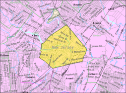
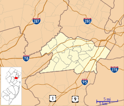
 Location of Rahway in Union County, New Jersey (left). Inset map: Location of Union County in New Jersey. | |
 | |
| Coordinates: 40°36′26″N 74°16′50″W / 40.607152°N 74.280531°W[1] | |
| Country | |
| State | |
| County | Union |
| Incorporated | April 19, 1858 |
| Government | |
| • Type | Faulkner Act (mayor–council) |
| • Body | City Council |
| • Mayor | Raymond A. Giacobbe Jr. (D, term ends December 31, 2026)[2][3] |
| • Business administrator | Jonathan Parham[4] |
| • Municipal clerk | Jeffrey Jotz[5] |
| Area | |
• Total | 4.04 sq mi (10.47 km2) |
| • Land | 3.90 sq mi (10.09 km2) |
| • Water | 0.14 sq mi (0.38 km2) 3.59% |
| • Rank | 295th of 565 in state 12th of 21 in county[8] |
| Elevation | 23 ft (7 m) |
| Population | |
• Total | 29,556 |
| 29,813 | |
| • Rank | 81st of 565 in state 6th of 21 in county[12] |
| • Density | 7,586.2/sq mi (2,929.0/km2) |
| • Rank | 58th of 565 in state 7th of 21 in county[12] |
| Time zone | UTC−05:00 (Eastern Standard Time (EST)) |
| • Summer (DST) | UTC−04:00 (Eastern (EDT)) |
| ZIP Code | |
| Area code(s) | 732[15] |
| FIPS code | 3403961530[8][16][17] |
| GNIS feature ID | 0885363[1] |
| Website | www |


Rahway (/ˈrɔːweɪ/) is a city in southern Union County, in the U.S. state of New Jersey. A bedroom community of New York City, it is centrally located in the Rahway Valley region, in the New York metropolitan area.[18] The city is 15 miles (24 km) southwest of Manhattan and 5 miles (8.0 km) west of Staten Island.
Built on the navigable Rahway River, it was an industrial and artisanal craft city for much of its history. The city has increasingly reinvented itself in recent years as a diverse regional hub for the arts[19][20] and biological sciences, with a new global headquarters for Merck & Co.
As of the 2020 United States census, the city's population was 29,556,[9][10] its highest decennial count ever and an increase of 2,210 (+8.1%) from the 27,346 recorded at the 2010 census,[21][22] which in turn reflected an increase of 846 (+3.2%) from the 26,500 counted in the 2000 census.[23]
- ^ a b c "City of Rahway". Geographic Names Information System. United States Geological Survey, United States Department of the Interior.
- ^ Cite error: The named reference
Mayorwas invoked but never defined (see the help page). - ^ 2023 New Jersey Mayors Directory, New Jersey Department of Community Affairs, updated February 8, 2023. Accessed February 10, 2023.
- ^ Business Administrator, City of Rahway. Accessed March 5, 2023.
- ^ Municipal Clerk, City of Rahway. Accessed March 5, 2023.
- ^ Cite error: The named reference
DataBookwas invoked but never defined (see the help page). - ^ "ArcGIS REST Services Directory". United States Census Bureau. Retrieved October 11, 2022.
- ^ a b 2019 Census Gazetteer Files: New Jersey Places, United States Census Bureau. Accessed July 1, 2020.
- ^ a b c Cite error: The named reference
Census2020was invoked but never defined (see the help page). - ^ a b Cite error: The named reference
LWD2020was invoked but never defined (see the help page). - ^ Cite error: The named reference
PopEstwas invoked but never defined (see the help page). - ^ a b Population Density by County and Municipality: New Jersey, 2020 and 2021, New Jersey Department of Labor and Workforce Development. Accessed March 1, 2023.
- ^ Look Up a ZIP Code for Rahway, NJ, United States Postal Service. Accessed May 20, 2012.
- ^ Zip Codes, State of New Jersey. Accessed September 14, 2013.
- ^ Area Code Lookup - NPA NXX for Rahway, NJ, Area-Codes.com. Accessed September 14, 2013.
- ^ U.S. Census website, United States Census Bureau. Accessed September 4, 2014.
- ^ Geographic codes for New Jersey, Missouri Census Data Center. Accessed April 1, 2022.
- ^ Capuzzo, Jill P. "Living In Rahway, N.J.: Changes to Cheer About. Really.", The New York Times, May 6, 2007. Accessed December 4, 2023.
- ^ Kudisch, Brianna. "This small N.J. city has been quietly reinventing itself into an arts hub", NJ Advance Media for NJ.com, February 15, 2020. Accessed February 22, 2022. "Rahway, she said, has spent the last 20 years working to fill its streets with art, music, comedy, and theater in the hopes that they would spur additional development throughout the Union County city of 30,000."
- ^ "Rahway Adds to Its Resume as Hub for the Arts", New Jersey Monthly, July 16, 2012. Accessed February 22, 2022. "In recent years, the arts have been central to the city’s revitalization plans, as highlighted by the 2008 launch of the Union County Performing Arts Center in the renovated Rahway Theater. Now as an extension of UC PAC, comes the sparkling new Hamilton Stage for the Performing Arts, which will open its doors in September."
- ^ Cite error: The named reference
Census2010was invoked but never defined (see the help page). - ^ Cite error: The named reference
LWD2010was invoked but never defined (see the help page). - ^ Table 7. Population for the Counties and Municipalities in New Jersey: 1990, 2000 and 2010, New Jersey Department of Labor and Workforce Development, February 2011. Accessed May 1, 2023.


