Back রাজপুতানা Bengali/Bangla Rajputana Catalan Ρατζπουτάνα Greek Rajputana Spanish ראג'פוטנה HE राजपुताना Hindi Rajputana Croatian Rajputana ID Rajputana Italian ラージプーターナー Japanese


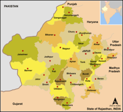
Rājputana, meaning Land of the Rajputs,[1] was a region in the Indian subcontinent that included mainly the present-day Indian state of Rajasthan, as well as parts of Madhya Pradesh and Gujarat,[1] and some adjoining areas of Sindh in modern-day southern Pakistan.[2]
The main settlements to the west of the Aravalli Hills came to be known as Rajputana, early in the Medieval Period.[3] The name was later adopted by East India Company as the Rajputana Agency for its dependencies in the region of the present-day Indian state of Rājasthān.[4] The Rajputana Agency included 26 Rajput and 2 Jat princely states and two chiefships. This official term remained until its replacement by "Rajasthan" in the constitution of 1949.[4]
- ^ a b "Rajputana". Encyclopædia Britannica.
- ^ "Rajput". Encyclopædia Britannica.
- ^ Bose, Manilal (1998). Social Cultural History of Ancient India. Concept Publishing Company. p. 27. ISBN 978-81-702-2598-0.
- ^ a b R.K. Gupta; S.R. Bakshi (1 January 2008). Studies In Indian History: Rajasthan Through The Ages The Heritage Of Rajputana (Set Of 5 Vols.). Sarup & Sons. pp. 143–. ISBN 978-81-7625-841-8. Retrieved 30 October 2012.