Back راما (كولورادو) Arabic راما (بلد) ARZ راماه، کولورادو AZB Ramah (Colorado) Catalan Рама (Колорадо) CE Ramah (lungsod sa Tinipong Bansa, Colorado) CEB Ramah, Colorado Welsh Ramah (Colorado) Spanish Ramah (Colorado) Basque راماه، کلرادو Persian
Ramah, Colorado | |
|---|---|
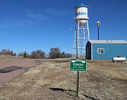
 Entering Ramah on Commercial Street. | |
 Location of Ramah in El Paso County, Colorado. | |
| Coordinates: 39°07′24″N 104°10′05″W / 39.12333°N 104.16806°W | |
| Country | |
| State | |
| County[1] | El Paso |
| Incorporated (town) | July 18, 1927[2] |
| Government | |
| • Type | Statutory Town[1] |
| Area | |
• Total | 0.25 sq mi (0.64 km2) |
| • Land | 0.25 sq mi (0.64 km2) |
| • Water | 0.00 sq mi (0.00 km2) |
| Elevation | 6,099 ft (1,859 m) |
| Population | |
• Total | 111 |
| • Density | 440/sq mi (170/km2) |
| Time zone | UTC-7 (Mountain (MST)) |
| • Summer (DST) | UTC-6 (MDT) |
| ZIP code | 80832 |
| Area code | 719 |
| FIPS code | 08-62660 |
| GNIS feature ID | 2412523[4] |
| Website | ramah |
Ramah /ˈreɪmə/ is a Statutory Town in El Paso County, Colorado, United States. The population was 111 as of the 2020 census.[5] According to tradition, the name is derived from India.[6]
- ^ a b "Active Colorado Municipalities". State of Colorado, Department of Local Affairs. Archived from the original on December 12, 2009. Retrieved September 1, 2007.
- ^ "Colorado Municipal Incorporations". State of Colorado, Department of Personnel & Administration, Colorado State Archives. December 1, 2004. Retrieved September 2, 2007.
- ^ "2019 U.S. Gazetteer Files". United States Census Bureau. Retrieved July 1, 2020.
- ^ a b U.S. Geological Survey Geographic Names Information System: Ramah, Colorado
- ^ a b United States Census Bureau. "Ramah town; Colorado". Retrieved April 24, 2023.
- ^ Dawson, John Frank. Place names in Colorado: why 700 communities were so named, 150 of Spanish or Indian origin. Denver, CO: The J. Frank Dawson Publishing Co. p. 43.