Ranni | |
|---|---|
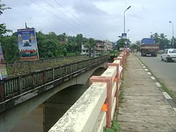
 The dilapidated old bridge and new bridge at Ranni | |
| Coordinates: 9°22′0″N 76°46′0″E / 9.36667°N 76.76667°E | |
| Country | India |
| State | Kerala |
| District | Pathanamthitta |
| Government | |
| • Type | Taluk |
| Area | |
• Total | 1,004 km2 (388 sq mi) |
| Elevation | 331 m (1,086 ft) |
| Population (2011)[1] | |
• Total | 198,194 |
| • Density | 200/km2 (510/sq mi) |
| Languages | |
| • Official | Malayalam, English |
| Time zone | UTC+5:30 (IST) |
| PIN | 689672 |
| Telephone code | 04735 |
| Vehicle registration | KL-62 |
| Nearest city | Thiruvalla |
| Sex ratio | 47:50 ♂/♀ |
| Literacy | 95% |
| Lok Sabha constituency | Pathanamthitta |
Ranni or Ranny is a town in the Pathanamthitta district of Kerala, India, and the 16th largest taluk in Kerala, located on both sides of the Pamba River.It Comes Under Thiruvalla Revenue Division.It Is located 27 km from Thiruvalla railway station & NH 183 in Thiruvalla.
- ^ https://censusindia.gov.in › 3...PDF Pathanamthitta - DISTRICT CENSUS HANDBOOK


