Back راینهام، ماساچوست AZB Raynham (Massachusetts) Catalan Рейнгем (Массачусетс) CE Raynham (lungsod) CEB Raynham, Massachusetts Welsh Raynham (Massachusetts) Spanish Raynham (Massachusetts) Basque رایهام، ماساچوست Persian Raynham (Massachusetts) French Raynham, Massachusetts HT
Raynham, Massachusetts | |
|---|---|
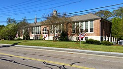
 Raynham Town Hall | |
 Location in Bristol County in Massachusetts | |
| Coordinates: 41°56′55″N 71°04′25″W / 41.94861°N 71.07361°W | |
| Country | United States |
| State | Massachusetts |
| County | Bristol |
| Settled | 1652 |
| Incorporated | 1731 |
| Government | |
| • Type | Open town meeting |
| Area | |
• Total | 20.9 sq mi (54.0 km2) |
| • Land | 20.5 sq mi (53.1 km2) |
| • Water | 0.4 sq mi (0.9 km2) |
| Elevation | 81 ft (25 m) |
| Population (2020) | |
• Total | 15,142 |
| • Density | 720/sq mi (280/km2) |
| Time zone | UTC−5 (Eastern) |
| • Summer (DST) | UTC−4 (Eastern) |
| ZIP Code | 02767 |
| Area code | 508/774 |
| FIPS code | 25-56060 |
| GNIS feature ID | 0618285 |
| Website | www.town.raynham.ma.us |
Raynham (/ˈreɪnəm/) is a town in Bristol County, Massachusetts, United States, located approximately 32 miles (51 km) south of Boston and 22 miles (35 km) northeast of Providence, Rhode Island. The population was 15,082 at the 2020 census.[1] It has one village, Raynham Center.
- ^ "Census - Geography Profile: Raynham town, Massachusetts". United States Census Bureau. Retrieved November 10, 2021.
