Back مقاطعة رينسيلير (نيويورك) Arabic Rensselaer County, New York BAR Ренсълийр (окръг, Ню Йорк) Bulgarian রেন্সসীলায়ের কাউন্টি, নিউ ইয়র্ক BPY Rensselaer Gông (New York) CDO Ренсселер (гуо, Нью-Йорк) CE Rensselaer County CEB Rensselaer County Czech Rensselaer County, Efrog Newydd Welsh Rensselaer County German
Rensselaer County | |
|---|---|
 Rensselaer County Courthouse | |
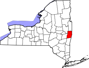
 Location within the U.S. state of New York | |
 New York's location within the U.S. | |
| Coordinates: 42°42′36″N 73°29′24″W / 42.71000°N 73.49000°W | |
| Country | |
| State | |
| Founded | February 7, 1791[a] |
| Named for | Kiliaen van Rensselaer |
| Seat | Troy |
| Largest city | Troy |
| Area | |
• Total | 665 sq mi (1,720 km2) |
| • Land | 652 sq mi (1,690 km2) |
| • Water | 13 sq mi (30 km2) 1.9% |
| Population (2020) | |
• Total | 161,133[1] |
| • Density | 247.0/sq mi (95.4/km2) |
| Time zone | UTC−5 (Eastern) |
| • Summer (DST) | UTC−4 (EDT) |
| Congressional districts | 20th, 21st |
| Website | www |
Rensselaer County /rɛnsəˈlɪər/ ren-sə-LEER is a county in the U.S. state of New York. As of the 2020 census, the population was 161,130.[2] Its county seat is Troy.[3] The county is named in honor of the family of Kiliaen van Rensselaer, the original Dutch owner of the land in the area. The county is part of the Capital District region of the state.
Rensselaer County is part of the Albany-Schenectady-Troy, NY Metropolitan Statistical Area.
- ^ "US Census 2020 Population Dataset Tables for New York". United States Census Bureau. Retrieved January 2, 2022.
- ^ "U.S. Census Bureau QuickFacts: Rensselaer County, New York". United States Census Bureau. Retrieved January 2, 2022.
- ^ "Find a County". National Association of Counties. Retrieved June 7, 2011.
Cite error: There are <ref group=lower-alpha> tags or {{efn}} templates on this page, but the references will not show without a {{reflist|group=lower-alpha}} template or {{notelist}} template (see the help page).

