Back مقاطعة رينفيل (داكوتا الشمالية) Arabic Renville County, North Dakota BAR Ренвил (окръг, Северна Дакота) Bulgarian রেনভিল কাউন্টি, নর্থ ডাকোটা BPY Renville Gông (North Dakota) CDO Renville County (kondado sa Tinipong Bansa, North Dakota) CEB Renville County, Gogledd Dakota Welsh Renville County (North Dakota) German Condado de Renville (Dakota del Norte) Spanish Renville'i maakond (Põhja-Dakota) Estonian
Renville County | |
|---|---|
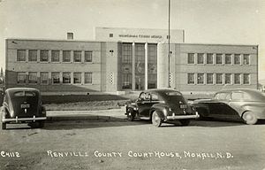
 Renville County Courthouse. Photographed in 1940. | |
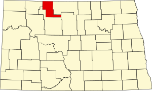
 Location within the U.S. state of North Dakota | |
 North Dakota's location within the U.S. | |
| Coordinates: 48°43′N 101°40′W / 48.71°N 101.66°W | |
| Country | |
| State | |
| Founded | January 4, 1873 (created) July 20, 1910 (organized) |
| Named for | Joseph Renville |
| Seat | Mohall |
| Largest city | Mohall |
| Area | |
• Total | 893 sq mi (2,310 km2) |
| • Land | 877 sq mi (2,270 km2) |
| • Water | 16 sq mi (40 km2) 1.8% |
| Population (2020) | |
• Total | 2,282 |
• Estimate (2022) | 2,220 |
| • Density | 2.6/sq mi (0.99/km2) |
| Time zone | UTC−6 (Central) |
| • Summer (DST) | UTC−5 (CDT) |
| Congressional district | At-large |
| Website | www |
Renville County is a county in the U.S. state of North Dakota. As of the 2020 census, the population was 2,282.[1] Its county seat is Mohall.[2]
Renville County is part of the Minot, ND Micropolitan Statistical Area. It is located south of the Canada–United States border with Saskatchewan.
- ^ "State & County QuickFacts". United States Census Bureau. Retrieved April 6, 2023.
- ^ "Find a County". National Association of Counties. Retrieved June 7, 2011.