Back الوادي المتصدع (محافظة) Arabic Рыфт-Валі Byelorussian Рыфт-Валей BE-X-OLD Разломна долина (провинция) Bulgarian Rift Valley (Kenya) Breton Província de la Vall del Rift Catalan Rift Valley (Kenya) Danish Rift Valley (Kenia) German Πεδιάδα Ριφτ (Κένυα) Greek Provinco Rifta Valo Esperanto
This article needs additional citations for verification. (August 2007) |
Rift Valley Province
Mkoa wa Bonde la Ufa | |
|---|---|
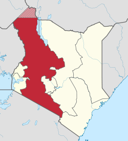
 Location in Kenya | |
| Coordinates: 0°30′N 36°0′E / 0.500°N 36.000°E | |
| Country | |
| No. of Counties: | 14 |
| Capital | Nakuru |
| Area | |
• Total | 182,505.1 km2 (70,465.6 sq mi) |
| Population (2009) | |
• Total | 10,006,805 |
| • Density | 55/km2 (140/sq mi) |
| Time zone | UTC+3 (EAT) |
Rift Valley Province (Swahili: Mkoa wa Bonde la Ufa) of Kenya, bordering Uganda, was one of Kenya's eight provinces, before the 2013 Kenyan general election. Rift Valley Province was the largest and one of the most economically important provinces in Kenya. It was dominated by the Kenya Rift Valley which passes through it and gave the province its name. According to the 2009 Census, the former province covered an area of 182,505.1 square kilometres (45,098,000 acres; 70,465.6 sq mi) and would have had a population of 10,006,805,[1][2] making it the largest and most populous province in the country. The bulk of the provincial population inhabited a strip between former Nairobi and Nyanza Province. The capital was the town of Nakuru.
- ^ "Archived copy" (PDF). Archived from the original (PDF) on August 10, 2013. Retrieved January 15, 2013.
{{cite web}}: CS1 maint: archived copy as title (link) - ^ "Kenya Census 2009".