Back Roanoke, Virginië Afrikaans Rōwrenoc (Firginiæ) ANG روانوك Arabic روانوک، ویرجینیا AZB Roanoke, Virginia BAR Роанак (Віргінія) Byelorussian Roanoke (Virginia) Breton Роенок (Виргини) CE Roanoke (kapital sa kondado) CEB Roanoke (Virginie) Czech
Roanoke, Virginia | |
|---|---|
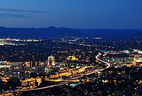
Clockwise from top: Downtown Roanoke, City market building, Basilica of St. Andrew, Hotel Roanoke, Roanoke Star | |
| Nickname(s): The Star City of The South, Magic City, Star City | |
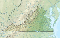
| Coordinates: 37°16′14″N 79°56′33″W / 37.27056°N 79.94250°W | |
| Country | United States |
| State | Virginia |
| Named for | Roanoke River |
| Government | |
| • Type | Council–manager |
| • Mayor | Joseph L. Cobb |
| • Vice mayor | Terry McGuire |
| Area | |
| 42.85 sq mi (110.99 km2) | |
| • Land | 42.52 sq mi (110.13 km2) |
| • Water | 0.33 sq mi (0.86 km2) |
| Elevation | 974 ft (297 m) |
| Population (2020) | |
| 100,011 | |
| • Rank | 326th in the United States 8th in Virginia |
| • Density | 2,300/sq mi (900/km2) |
| • Urban | 217,312 (US: 177th)[2] |
| • Urban density | 1,731.6/sq mi (668.6/km2) |
| • Metro | 315,251 (US: 163rd) |
| Demonym | Roanoker |
| Time zone | UTC−5 (Eastern (EST)) |
| • Summer (DST) | UTC−4 (EDT) |
| ZIP Codes | 24001–24020, 24022–24038, 24040, 24042–24045, 24048, 24050, 24155, 24157, 24012 |
| Area code(s) | 540, 826 |
| FIPS code | 51-77000[4] |
| GNIS feature ID | 1499971[5] |
| Website | www |
Roanoke (/ˈroʊ.əˌnoʊk/ ROH-ə-nohk) is an independent city in Virginia, United States. It is located in Southwest Virginia along the Roanoke River, in the Blue Ridge range of the greater Appalachian Mountains. Roanoke is approximately 50 miles (80 km) north of the Virginia–North Carolina border and 250 miles (400 km) southwest of Washington, D.C., along Interstate 81. At the 2020 census, Roanoke's population was 100,011, making it the most-populous city in Virginia west of the state capital Richmond.[6] It is the primary population center of the Roanoke metropolitan area, which had a population of 315,251 in 2020.
The Roanoke Valley was originally home to members of the Siouan-speaking Tutelo tribe. However, in the 17th and early-to-mid 18th centuries, Scotch-Irish and later German American farmers gradually drove those Native Americans out of the area as the American frontier pressed westward. In 1882, the Norfolk and Western Railway (N&W) chose the small town of Big Lick as the site of its corporate headquarters and railroad shops. Within two years, the town had become the City of Roanoke. With a 2,300% population growth rate in the decade from 1880 to 1890, the young city experienced the advantages and disadvantages of its boomtown status. During the 20th century, Roanoke's boundaries expanded through multiple annexations from the surrounding Roanoke County, and it became Southwest Virginia's economic and cultural hub. The 1982 decision by N&W to relocate their headquarters out of the city, combined with other manufacturing closures, led Roanoke to pivot to a primarily service economy. In the 21st century, a robust healthcare industry and the development and increased marketing of its outdoor amenities have helped reverse prior declining population trends.
Roanoke is known for the Roanoke Star, an 88.5-foot-tall (27.0 m) illuminated star that sits atop a mountain within the city's limits and is the origin of its nickname, "The Star City of the South". Other points of interest include the Hotel Roanoke, a 330-room Tudor Revival structure built by N&W in 1882, the Taubman Museum of Art, designed by architect Randall Stout, and the city's farmer's market, the oldest continuously operating open-air market in the state. The Roanoke Valley features 26 miles (42 km) of greenways with bicycle and pedestrian trails, and the city's location in the Blue Ridge Mountains provides access to numerous outdoor recreation opportunities.
- ^ "2019 U.S. Gazetteer Files". United States Census Bureau. Archived from the original on October 16, 2020. Retrieved August 7, 2020.
- ^ "List of 2020 Census Urban Areas". census.gov. United States Census Bureau. Archived from the original on January 14, 2023. Retrieved January 7, 2023.
- ^ "U.S. Geological Survey Geographic Names Information System: Roanoke Virginia". United States Geological Survey. Retrieved December 20, 2023.
- ^ "U.S. Census website". United States Census Bureau. Archived from the original on July 9, 2021. Retrieved January 31, 2008.
- ^ "US Board on Geographic Names". United States Geological Survey. October 25, 2007. Archived from the original on December 25, 2018. Retrieved January 31, 2008.
- ^ "QuickFacts Roanoke city, Virginia". United States Census Bureau. Archived from the original on June 22, 2021. Retrieved September 7, 2021.


