Back Урубамба Bulgarian Valle Sagrado German Urubamba Valo Esperanto Valle Sagrado de los Incas Spanish Inken Haran Sakratua Basque Vallée sacrée des Incas French Val Sagrado dos Incas Galician העמק הקדוש HE Urubamba (dolina) Croatian Valle sacra degli Incas Italian
| Sacred Valley | |
|---|---|
| Urubamba Valley | |
 Sacred Valley of the Incas | |
| Geography | |
| Coordinates | 13°20′S 72°05′W / 13.333°S 72.083°W |
| River | Urubamba River |


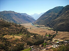
The Sacred Valley of the Incas (Spanish: Valle Sagrado de los Incas; Quechua: Willka Qhichwa), or the Urubamba Valley, is a valley in the Andes of Peru, north of the Inca capital of Cusco. It is located in the present-day Peruvian region of Cusco. In colonial documents it was referred to as the "Valley of Yucay". The Sacred Valley was incorporated slowly into the incipient Inca Empire during the period from 1000 to 1400.[1]
The Sacred Valley is a major tourist destination. In 2019, 1.6 million people, the majority non-Peruvians, visited Machu Picchu,[2] its most famous archaeological site. Many of the same tourists also visited other archaeological sites and modern towns in the Sacred Valley.
Stretching from Pisac to Ollantaytambo, this fertile valley is irrigated by the Urubamba River. The Chanapata civilisation first utilised this area starting at around 800 BCE because of its rich soil used for agriculture. The Qotacalla civilization lived in the Sacred Valley from 500 to 900 CE. The Killke civilization then flourished in the Sacred Valley from 900 until it was absorbed into the Incan Empire in 1420. The Incan Empire ruled this area for little more than 100 years until the arrival of the Spanish.

- ^ Bauer, Brian S.; Covey, R. Alan (2002). "Processes of State Formation in the Inca Heartland (Cuzco, Peru)". American Anthropologist. 104 (3): 846–64. doi:10.1525/aa.2002.104.3.846.
- ^ Glazier, Elysia (2023-11-18). "How Many Tourists Visit Machu Picchu Every Year". TouristSecrets. Retrieved 2024-01-04.
