Back شلالات سانت أنتوني Arabic Vodopády svatého Antonína Czech Saint-Anthony-Fälle German Cataratas de San Antonio Spanish آبشار سنت آنتونی Persian Saint Anthonyn putous Finnish Chutes de Saint Anthony French Սուրբ Անտոնիոյի ջրվեժ Armenian セントアンソニー滝 Japanese 세인트앤서니 폭포 Korean
| Saint Anthony Falls | |
|---|---|
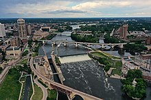
 Saint Anthony Falls with the upper lock and dam, viewed from downstream | |
 | |
| Location | Mississippi River into the Mississippi River Gorge in Minneapolis, Minnesota |
| Coordinates | 44°58′54″N 93°15′31″W / 44.98167°N 93.25861°W |
| Type | Block |
| Total height | 49 ft (15 m) |
| Number of drops | 1 |
| Watercourse | Mississippi River |
| Average flow rate | 13,000 cu ft/s (370 m3/s) |
| Location | Minneapolis, Minnesota |
| Part of | St. Anthony Falls Historic District (ID71000438[1]) |
| Added to NRHP | March 11, 1971 |
Saint Anthony Falls, or the Falls of Saint Anthony (Dakota: Owámniyomni, lit. 'whirlpool'[2]), located at the northeastern edge of downtown Minneapolis, Minnesota, was the only natural major waterfall on the Mississippi River. Throughout the mid-to-late 1800s, various dams were built atop the east and west faces of the falls to support the milling industry that spurred the growth of the city of Minneapolis. In 1880, the central face of the falls was reinforced with a sloping timber apron to stop the upstream erosion of the falls. In the 1950s, the apron was rebuilt with concrete, which makes up the most visible portion of the falls today. A series of locks were constructed in the 1950s and 1960s to extend navigation to points upstream.[3]
The falls were renamed from their Dakota title in 1680 by Father Louis Hennepin after his patron saint, St. Anthony of Padua. The towns of St. Anthony[4] and Minneapolis, which had developed on the east and west sides of the falls, respectively, merged in 1872 to fully use the power of the falls for milling operations. From 1880 to about 1930, Minneapolis was known as the "Flour Milling Capital of the World".[5]
Today, the falls are defined by the spillway, the upper dam and the locks, located just downstream of the 3rd Avenue Bridge, and the Lower Lock and Dam, just upstream of the I-35W Saint Anthony Falls Bridge.[6] These locks were built as part of the Upper Mississippi River 9-Foot Navigation Project. The area around the falls is designated the St. Anthony Falls Historic District[7] and features a 1.8-mile (2.9 km) self-guided walking trail with signs explaining the area's past.
- ^ "National Register Information System". National Register of Historic Places. National Park Service. March 15, 2006.
- ^ Westerman, Gwen; White, Bruce (2012). Mni Sota Makoce: The Land of the Dakota. St. Paul, Minnesota: Minnesota Historical Society Press. ISBN 9780873518833.
- ^ "St. Paul District > Missions > Navigation > Locks & Dams > Upper St. Anthony Falls". www.mvp.usace.army.mil.
- ^ Not to be confused with the modern St. Anthony Village - "St. Anthony History". Saint Anthony Village. Retrieved April 9, 2024.
- ^ "Mill City Museum History of St Anthony". Mill City Museum. 2005. Archived from the original on May 13, 2007.
- ^ "St. Paul District > Missions > Navigation > Locks & Dams > Lower St. Anthony Falls". www.mvp.usace.army.mil.
- ^ "St. Anthony Falls Historic District". City of Minneapolis. 2006.
