Back Saïs Afrikaans صا الحجر Arabic صا الحجر ARZ سائیس AZB Саіс Byelorussian Саис Bulgarian Sais Catalan Sau Czech Sais German Σάις Greek
Sais | |
|---|---|
 Map of Sais ruins drawn by Jean-François Champollion during his expedition in 1828 | |
| Coordinates: 30°57′53″N 30°46′6″E / 30.96472°N 30.76833°E | |
| Country | |
| Governorate | Gharbia |
| Time zone | UTC+2 (EST) |

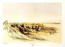
Sais (Ancient Greek: Σάϊς, Coptic: Ⲥⲁⲓ) was an ancient Egyptian city in the Western Nile Delta on the Canopic branch of the Nile,[1] known by the ancient Egyptians as Sꜣw.[2] It was the provincial capital of Sap-Meh, the fifth nome of Lower Egypt and became the seat of power during the Twenty-fourth Dynasty of Egypt (c. 732–720 BC) and the Saite Twenty-sixth Dynasty of Egypt (664–525 BC) during the Late Period.[3] On its ruins today stands the town of Sa el-Hagar[2][4] (Egyptian Arabic: صا الحجر) or Sa El Hajar.
| Sais in hieroglyphs | ||||||
|---|---|---|---|---|---|---|
Sau (Zau) Sȝw | ||||||
| Greek | Σάϊς (Sais) | |||||
- ^ Mish, Frederick C., Editor in Chief. "Saïs." Webster's Ninth New Collegiate Dictionary. 9th ed. Springfield, MA: Merriam-Webster Inc., 1985. ISBN 0-87779-508-8, ISBN 0-87779-509-6 (indexed), and ISBN 0-87779-510-X (deluxe).
- ^ a b Myśliwiec, Karol (2001). "Sais". In Redford, Donald B. (ed.). The Oxford Encyclopedia of Ancient Egypt, Volume 3. Oxford: Oxford University Press. pp. 173–4. ISBN 978-0-19-510234-5.
- ^ Ian Shaw & Paul Nicholson, The Dictionary of Ancient Egypt, British Museum Press, 1995. p.250
- ^ Snape, Steven (2014). The Complete Cities of Ancient Egypt. Thames & Hudson. ISBN 978-0-500-77240-9.
