Back جزيرة الملح (جزر توركس) Arabic Salt Cay (pulo sa Kapupud-an Turks ug Kaikos) CEB Salt Cay (Turks-Inseln) German Cayo Sal (Islas Turcas y Caicos) Spanish Salt Cay (îles Turques) French Caio Sal Galician Salt Cay Italian Salt Cay Dutch Salt Cay Polish Солт-Кей (остров) Russian
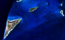
 Satellite Image of Salt Cay (lower left) and neighboring islets | |
 The location of Salt Cay within the Turks and Caicos Islands | |
| Geography | |
|---|---|
| Location | Atlantic Ocean |
| Coordinates | 21°19′30″N 71°12′30″W / 21.32500°N 71.20833°W |
| Archipelago | Lucayan Archipelago |
| Administration | |
United Kingdom | |
| British Overseas Territory | Turks and Caicos Islands |
| Demographics | |
| Population | 108 (2012)[1] |
| Additional information | |
| Time zone | |
| • Summer (DST) | |
| ISO code | TC |
Salt Cay is the second largest of the Turks Islands, one of the two island groups forming of the British territory of the Turks and Caicos Islands in the Caribbean. Its area is 6.74 square kilometres (2.60 square miles). The size of the district, which also includes some unpopulated islands like Cotton Cay (1.1252 square kilometres or 0.434 square miles) nearby, is 9.1 square kilometres (3.5 square miles). The population is 108 (est. 2012),[1] all in the district capital Balfour Town, established in 1673, on the west coast.
Salt Cay is a tiny, flat, triangular island measuring about 3.2 kilometres (2.0 miles) on a side and given over mostly to salt pans. It was once home to several hundred people, all supported by the salt industry.
Salt Cay is accessible via plane; Caicos Express Airways flies there from both Providenciales and Grand Turk islands. From Grand Turk there is also a "community ferry", which operates three times a week and takes about one hour to cover the 13-kilometre (8.1 mi) distance.
- ^ a b "Population 2012 census". Government of Turks and Caicos. Retrieved 15 May 2021.

