Back Salzburger Schieferalpen German Salzburger Schieferalpen Esperanto Salzburgi Kiltkivialpid Estonian Alpi Scistose Salisburghesi Italian Salzburger Schieferalpen NB Salzburger Schieferalpen Polish Alpes xistosos de Salisburgo Portuguese Salzburške kristalinske Alpe Slovenian 薩爾斯堡板岩阿爾卑斯山脈 Chinese
| Salzburg Slate Alps | |
|---|---|
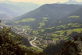
 Salzach valley with Burg Hohenwerfen | |
| Highest point | |
| Peak | Hundstein |
| Elevation | 2,117 m (6,946 ft) |
| Coordinates | 47°20′17″N 12°54′40″E / 47.33806°N 12.91111°E |
| Dimensions | |
| Length | 60 km (37 mi) |
| Width | 10 km (6.2 mi) |
| Geography | |
 Salzburg Slate Alps (in red) within the Alps. Borders of the range according to the Alpine Club classification of the Eastern Alps | |
| Country | Austria |
| State | Salzburg |
| Range coordinates | 47°23′N 13°13′E / 47.39°N 13.21°E |
| Parent range | Northern Limestone Alps |
| Geology | |
| Rock age | Paleozoic-Early Triassic |
| Rock type | Greywacke zone/Werfen Formation |
The Salzburg Slate Alps (German: Salzburger Schieferalpen) are a mountain range of the Eastern Alps, in the Austrian state of Salzburg. Situated within the greywacke zone, they could be regarded either as part of the Northern Limestone Alps or of the Central Eastern Alps.