Back سان ليندرو (كاليفورنيا) Arabic سان لياندرو (كاليفورنيا) ARZ سان لیندرو، کالیفورنیا AZB Сан Леандро Bulgarian San Leandro Catalan Сан-Леандро (Калифорни) CE San Leandro (lungsod sa Tinipong Bansa) CEB San Leandro (Kalifornie) Czech San Leandro DAG San Leandro German
San Leandro, California | |
|---|---|
| City of San Leandro | |
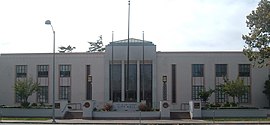
Clockwise, from top: San Leandro City Hall, Peralta Home, Casa Peralta | |
| Nickname: SL[a] | |
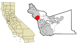
 Location within Alameda County | |
| Coordinates: 37°43′30″N 122°09′22″W / 37.72500°N 122.15611°W | |
| Country | |
| State | |
| County | Alameda |
| Region | San Francisco Bay Area |
| Incorporated | March 21, 1872[1] |
| Named for | St. Leander of Seville[2] |
| Government | |
| • Type | Council–Manager[3] |
| • Mayor[9] | Juan González III |
| • Council members by district number[9] |
|
| • City manager | Janelle Cameron[4][5] |
| • State Legislators (AD-18 & SD-9) | Asm. Mia Bonta (D)[6] Sen. Tim Grayson (D)[7] |
| • U.S. Representative (CA-12) | Lateefah Simon (D)[8] |
| Area | |
• Total | 15.52 sq mi (40.19 km2) |
| • Land | 13.32 sq mi (34.51 km2) |
| • Water | 2.19 sq mi (5.68 km2) 14.81% |
| Elevation | 56 ft (17 m) |
| Population | |
• Total | 91,008 |
| • Rank | 97th in California |
| • Density | 5,900/sq mi (2,300/km2) |
| Demonym | San Leandran[13] |
| Time zone | UTC–8 (Pacific (PST)) |
| • Summer (DST) | UTC–7 (PDT) |
| ZIP Codes | 94577–94579 |
| Area code(s) | 510, 341 |
| FIPS code | 06-68084 |
| GNIS feature IDs | 232427, 1659582, 2411794 |
| Website | www |
San Leandro (Spanish for "St. Leander") is a city in Alameda County, California, United States. It is located in the East Bay of the San Francisco Bay Area; between Oakland to the northwest, and Ashland, Castro Valley, and Hayward to the southeast. The population was 91,008 as of the 2020 census.[12]
Cite error: There are <ref group=lower-alpha> tags or {{efn}} templates on this page, but the references will not show without a {{reflist|group=lower-alpha}} template or {{notelist}} template (see the help page).
- ^ "California Cities by Incorporation Date". California Association of Local Agency Formation Commissions. Archived from the original (Word) on November 3, 2014. Retrieved March 27, 2013.
- ^ Simons 2008, p. 8.
- ^ "Comprehensive Annual Financial Report". City of San Leandro. 2019. p. vi. Archived from the original on October 3, 2020.
- ^ "City Manager". City of San Leandro. Retrieved January 15, 2025.
{{cite web}}: CS1 maint: url-status (link) - ^ "City Manager Appointed" (Press release). City of San Leandro. May 4, 2021.
- ^ "Members Assembly". State of California. Retrieved March 18, 2013.
- ^ "Senators". State of California. Retrieved March 18, 2013.
- ^ "California's 12th Congressional District - Representatives & District Map". Civic Impulse, LLC. Retrieved March 13, 2013.
- ^ a b "Mayor & City Council". City of San Leandro. Retrieved January 15, 2025.
- ^ "2019 U.S. Gazetteer Files". United States Census Bureau. Retrieved July 1, 2020.
- ^ "San Leandro". Geographic Names Information System. United States Geological Survey, United States Department of the Interior.
- ^ a b "U.S. Census Bureau QuickFacts: San Leandro city, California". United States Census Bureau. Retrieved September 26, 2021.
- ^ "PRESS RELEASE CMO2020-03-16-20". City of San Leandro. March 16, 2020.
- ^ "Population and Housing Unit Estimates". United States Census Bureau. May 24, 2020. Retrieved May 27, 2020.


