Back سنت لوئیس ری، کالیفورنیا AZB San Luis Rey (California) Spanish سنت لوئیس ری، کالیفرنیا Persian 聖路易斯雷 (加利福尼亞州) Chinese
This article needs to be updated. (January 2013) |
San Luis Rey | |
|---|---|
| Coordinates: 33°13′55″N 117°19′25″W / 33.23194°N 117.32361°W | |
| Country | United States |
| State | California |
| County | San Diego |
| Elevation | 59 ft (18 m) |
| Time zone | UTC-8 (Pacific (PST)) |
| • Summer (DST) | UTC-7 (PDT) |
| ZIP code | 92068 |
| Area code(s) | 442 & 760 |
| GNIS feature ID | 1661386[1] |
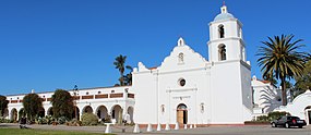
San Luis Rey (Spanish for "St. Louis the King") is a neighborhood in Oceanside, California. San Luis Rey is along the San Luis Rey River, 4 miles (6.4 km) northeast of downtown Oceanside. San Luis Rey has a post office with ZIP Code 92068, which opened in 1861.[2]
- ^ "US Board on Geographic Names". United States Geological Survey. October 25, 2007. Retrieved January 31, 2008.
- ^ ZIP Code Lookup


