Back مقاطعة سان ماتيو (كاليفورنيا) Arabic سان ماتييو كاونتى (كاليفورنيا) ARZ Condáu de San Mateo AST San-Mateo qraflığı (Kaliforniya) Azerbaijani San Mateo County, Kalifornien BAR Сан-Матэа (акруга) Byelorussian Сан Матео (окръг) Bulgarian সান মাতেউ কাউন্টি, ক্যালিফোর্নিয়া BPY Comtat de San Mateo Catalan Сан-Матео (гуо, Калифорни) CE
San Mateo County | |
|---|---|
| County of San Mateo | |
|
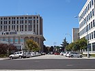
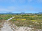
Images, from top down, left to right: View of San Francisco Bay from the San Francisco Bay Discovery Site, San Mateo County Government Center, Año Nuevo State Park | |
| Motto: All of California in One County | |
 Interactive map of San Mateo County | |
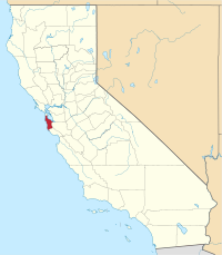
 Location in California | |
| Coordinates: 37°26′N 122°22′W / 37.44°N 122.36°W | |
| Country | United States |
| State | California |
| Incorporated | April 19, 1856[1] |
| Named for | Saint Matthew (English translation) |
| County seat and largest city by area | Redwood City |
| Largest city by population | San Mateo |
| Government | |
| • Type | Council–CEO |
| • Body | Board of Supervisors |
| • President[2] | Warren Slocum |
| • Vice President[3] | David Canepa |
| • Board of Supervisors[4] | Supervisors
|
| • County executive officer | Mike Callagy |
| Area | |
• Total | 744 sq mi (1,930 km2) |
| • Land | 448 sq mi (1,160 km2) |
| • Water | 293 sq mi (760 km2) |
| Highest elevation | 2,603 ft (793 m) |
| Population | |
• Total | 764,442 |
| • Density | 1,704/sq mi (658/km2) |
| GDP | |
| • Total | $177.912 billion (2022) |
| Time zone | UTC-8 (Pacific Time Zone) |
| • Summer (DST) | UTC-7 (Pacific Daylight Time) |
| Area codes | 415/628, 650 |
| FIPS code | 06-081 |
| GNIS feature ID | 277305 |
| Congressional districts | 15th, 16th |
| Website | www |
San Mateo County (/ˌsæn məˈteɪ.oʊ/ ⓘ SAN mə-TAY-oh), officially the County of San Mateo, is a county located in the U.S. state of California. As of the 2020 census, the population was 764,442.[8] Redwood City is the county seat,[9] the third-most populated city in the county after Daly City and San Mateo.
San Mateo County is included in the San Francisco–Oakland–Berkeley, CA MSA (metropolitan statistical area), Silicon Valley, and is part of the San Francisco Bay Area, the nine counties bordering San Francisco Bay. As of 2020, it has a median household income of $128,091, the fourth-highest household income of any county in the nation behind Loudoun County, Virginia, Falls Church, Virginia, and Santa Clara County, California.
The county covers most of the San Francisco Peninsula. The county is predominantly suburban and is home to many corporate campuses.
- ^ "San Mateo County". Geographic Names Information System. United States Geological Survey, United States Department of the Interior. Retrieved February 1, 2015.
- ^ "District 1 | County of San Mateo, CA". www.smcgov.org.
- ^ "District 4 | County of San Mateo, CA". www.smcgov.org.
- ^ "Board of Supervisors | County of San Mateo, CA".
- ^ "Long Ridge". Peakbagger.com. Retrieved February 9, 2015.
- ^ "State & County QuickFacts". United States Census Bureau. Archived from the original on August 1, 2011. Retrieved April 6, 2016.
- ^ "Gross Domestic Product: All Industries in San Mateo County, CA". fred.stlouisfed.org.
- ^ "San Mateo County, California". United States Census Bureau. Retrieved January 30, 2022.
- ^ "Find a County". National Association of Counties. Retrieved June 7, 2011.


