Back نهر سانغامون Arabic نهر سانجامون ARZ Sangamon River CEB Sangamon River German Sangamon French סנגמון (נהר) HE Sangamon (rijeka) Croatian സാംഗമൺ നദി Malayalam Sangamon (elv) NB სანგამონი XMF
| Sangamon River | |
|---|---|
 The Sangamon River near Decatur. | |
 | |
| Location | |
| Country | United States |
| Physical characteristics | |
| Source | |
| • location | Southern McLean County, Illinois |
| • coordinates | 40°26′43.12″N 88°43′57.24″W / 40.4453111°N 88.7325667°W |
| Mouth | |
• location | Illinois River at Beardstown, Illinois |
• coordinates | 40°1′21.17″N 90°25′58.45″W / 40.0225472°N 90.4329028°W |
| Length | 246 mi (396 km) |
| Discharge | |
| • location | Oakford, Illinois |
| • average | 3,639 cu/ft. per sec.[1] |
| Basin features | |
| Progression | Illinois River — Mississippi River |
| River system | Mississippi River |
| Tributaries | |
| • right | Salt Creek |
| GNIS ID | 421688 |

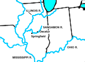
The Sangamon River is a principal tributary of the Illinois River, approximately 246 miles (396 km) long,[2] in central Illinois in the United States. It drains a mostly rural agricultural area and runs through Decatur and past Springfield. The river is associated with the early career of Abraham Lincoln, who was a sometime boatman working on the river, and played an important role in early European settlement of Illinois, when the area around was known as the "Sangamon River Country". The section of the Sangamon River that flows through Robert Allerton Park near Monticello was named a National Natural Landmark in 1971.
- ^ "USGS Current Conditions for USGS 05583000 SANGAMON RIVER NEAR OAKFORD, IL".
- ^ U.S. Geological Survey. National Hydrography Dataset high-resolution flowline data. The National Map, accessed May 13, 2011