Back مقاطعة سارلاهي Arabic सर्लाही जिला AWA सर्लाही जिला Bihari সর্লাহী জেলা Bengali/Bangla সর্লাহী BPY Sarlahi District Danish Sarlahi German सर्लाही जिल्ला DTY بخش سارلاهی Persian Sarlahin piirikunta Finnish
This article should specify the language of its non-English content, using {{lang}}, {{transliteration}} for transliterated languages, and {{IPA}} for phonetic transcriptions, with an appropriate ISO 639 code. Wikipedia's multilingual support templates may also be used. (August 2021) |
Sarlahi District
सर्लाही जिल्ला | |
|---|---|
 | |
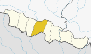
 Sarlahi District (dark yellow) in Madhesh Province | |
| Country | |
| Region | Mithila |
| Province | Madhesh |
| Admin HQ. | Malangwa |
| Government | |
| • Type | Coordination committee |
| • Body | DCC, Sarlahi |
| Area | |
• Total | 1,259 km2 (486 sq mi) |
| Population (2021) | |
• Total | 862,470 |
| • Density | 690/km2 (1,800/sq mi) |
| Time zone | UTC+05:45 (NPT) |
| Telephone Code | 046 |
| Main Language(s) | Bajjika, Maithili and Nepali |
| Website | www |
Sarlahi (Nepali: सर्लाही ⓘ; Maithili: सर्लाही), a part of Madhesh Province, is one of the seventy-seven districts of Nepal. According to new laws, a combination of more than two or four villages makes a municipality, which covers an area of 1,259 km2 (486 sq mi) and had a population of 635,701 in 2001,769,729 in 2011 and 862,470 in 2021 .[1]
It is bordered to the west by Rautahat district, to the east by Mahottari district, to the north by Sindhuli district of Bagmati Province, and to the south by the Indian state of Bihar.
- ^ "National Population and Housing Census 2011 (National Report)" (PDF). Central Bureau of Statistics. Archived from the original (PDF) on 2013-05-25. Retrieved 1 November 2012.