Back سارميدي Arabic سارمده AZB Сармеде Bulgarian Sarmede Breton Sarmede Catalan Сармеде CE Sarmede (munisipyo) CEB Sarmede German Σάρμεντε Greek Sarmede Esperanto
Sarmede | |
|---|---|
| Comune di Sarmede | |
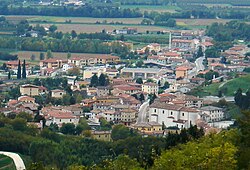
 Panorama of Sarmede | |
 | |
| Coordinates: 45°59′N 12°23′E / 45.983°N 12.383°E | |
| Country | Italy |
| Region | Veneto |
| Province | Province of Treviso (TV) |
| Area | |
• Total | 17.9 km2 (6.9 sq mi) |
| Population (Dec. 2022)[2] | |
• Total | 2,978 |
| • Density | 170/km2 (430/sq mi) |
| Time zone | UTC+1 (CET) |
| • Summer (DST) | UTC+2 (CEST) |
| Postal code | 31026 |
| Dialing code | 0438 |
| Website | Official website |
Sarmede is a comune (municipality) in the Province of Treviso in the Italian region Veneto, located about 60 kilometres (37 mi) north of Venice and about 35 kilometres (22 mi) northeast of Treviso. As of 31 December 2022, it had a population of 2,978 and an area of 17.9 square kilometres (6.9 sq mi).[3]
The village is famous for its frazione, Montaner, because during the 1970s the schism of Montaner occurred under the jurisdiction of the future Pope John Paul I.
Sarmede borders the following municipalities: Caneva, Cappella Maggiore, Cordignano, Fregona.
It is known as the land of fairy tales: this sort of "slogan" is due to Štěpán Zavřel, a Czechoslovakian painter who in 1982 had the idea of giving rise to an event in which to collect children's illustrations from different cultures: the International Children's Illustration Exhibition. In 1983, with the help of a group of volunteers from the Pro Loco of Sàrmede, the event took place, transforming streets and places into a real "fairytale village".[4]
- ^ "Superficie di Comuni Province e Regioni italiane al 9 ottobre 2011". Italian National Institute of Statistics. Retrieved 16 March 2019.
- ^ "Popolazione Residente al 1° Gennaio 2018". Italian National Institute of Statistics. Retrieved 16 March 2019.
- ^ All demographics and other statistics: Italian statistical institute Istat.
- ^ Il paese delle fiabe sarmede.org


