Back Sasbachwalden ALS Засбахвальден CE Sasbachwalden (munisipyo) CEB Sasbachwalden German Sasbachwalden Esperanto Sasbachwalden Spanish Sasbachwalden Basque زاسباخوالدن Persian Sasbachwalden French Sasbachwalden Hungarian
You can help expand this article with text translated from the corresponding article in German. (February 2009) Click [show] for important translation instructions.
|
Sasbachwalden | |
|---|---|
 Coat of arms | |
Location of Sasbachwalden within Ortenaukreis district 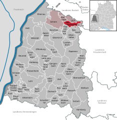 | |
 Sasbachwalden  Sasbachwalden | |
| Coordinates: 48°37′06″N 08°07′38″E / 48.61833°N 8.12722°E | |
| Country | Germany |
| State | Baden-Württemberg |
| Admin. region | Freiburg |
| District | Ortenaukreis |
| Government | |
| • Mayor (2024–32) | Sonja Schuchter[1] (CDU) |
| Area | |
• Total | 18.13 km2 (7.00 sq mi) |
| Elevation | 257 m (843 ft) |
| Population (2022-12-31)[2] | |
• Total | 2,604 |
| • Density | 140/km2 (370/sq mi) |
| Time zone | UTC+01:00 (CET) |
| • Summer (DST) | UTC+02:00 (CEST) |
| Postal codes | 77887 |
| Dialling codes | 07841 |
| Vehicle registration | OG, BH, KEL, LR, WOL |
| Website | www.sasbachwalden.de |
Sasbachwalden is a Black Forest municipality in Western Baden-Württemberg, Germany, popular with tourists. It is located on the western slopes of mountain Hornisgrinde in the Northern Black Forest and belongs to the district of Ortenau. More than 70% of the town area are forest.
- ^ Bürgermeisterwahl Sasbachwalden 2024, Staatsanzeiger. Retrieved 12 June 2024.
- ^ "Bevölkerung nach Nationalität und Geschlecht am 31. Dezember 2022" [Population by nationality and sex as of December 31, 2022] (CSV) (in German). Statistisches Landesamt Baden-Württemberg. June 2023.