Back Propinsi Savannakhet ACE محافظة سافاناكيت Arabic Khouèng Savannakhét CEB Provinz Savannakhet German Provinco Savannaĥet Esperanto Provincia de Savannakhet Spanish استان ساوانناکت Persian Savannakhet (provinssi) Finnish Province de Savannakhet French सवन्नाखेत प्रान्त Hindi
This article is written like a travel guide. (May 2020) |
Savannakhet province
ແຂວງ ສະຫວັນນະເຂດ | |
|---|---|
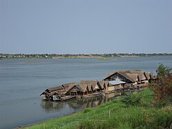
 A restaurant on the Mekong | |
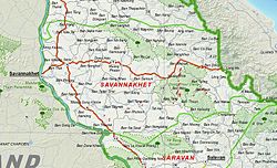
 Map of Savannakhet province | |
 Location of Savannakhet province in Laos | |
| Coordinates: 16°32′N 105°47′E / 16.54°N 105.78°E | |
| Country | |
| Capital | Savannakhet |
| Area | |
• Total | 21,774 km2 (8,407 sq mi) |
| Population (2020 census) | |
• Total | 1,037,553 |
| • Density | 48/km2 (120/sq mi) |
| Time zone | UTC+7 (ICT) |
| ISO 3166 code | LA-SV |
| HDI (2022) | 0.578[1] medium · 14th |


Savannakhet (Lao: ສະຫວັນນະເຂດ, pronounced [sā.wǎn nā(ʔ).kʰȅːt]) is a province of Laos. The name derives from Savanh Nakhone ('heavenly district' or 'land of fertility suitable for agriculture') the province's original name. The province is in the southern part of the country and is the largest province in Laos. It borders Khammouane province to the north, Quảng Trị and Thừa Thiên–Huế provinces of Vietnam to the east, Salavan province to the south, and Nakhon Phanom and Mukdahan provinces of Thailand to the west.
- ^ "Sub-national HDI - Area Database - Global Data Lab". hdi.globaldatalab.org. Retrieved 7 February 2025.