Back Схерпенхьовел-Зихем Bulgarian Scherpenheuvel-Zichem Breton Scherpenheuvel-Zichem Catalan Scherpenheuvel-Zichem CEB Scherpenheuvel-Zichem Czech Scherpenheuvel-Zichem German Scherpenheuvel-Zichem Esperanto Scherpenheuvel-Zichem Spanish Scherpenheuvel-Zichem Basque شرپنولزیشم Persian
This article needs additional citations for verification. (November 2020) |
Scherpenheuvel-Zichem | |
|---|---|
City and municipality | |
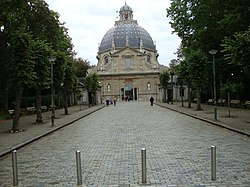
 Scherpenheuvel basilica | |
| Coordinates: 51°00′N 04°58′E / 51.000°N 4.967°E | |
| Country | |
| Community | Flemish Community |
| Region | Flemish Region |
| Province | Flemish Brabant |
| Arrondissement | Leuven |
| Government | |
| • Mayor | Manu Claes (CD&V) |
| • Governing party/ies | CD&V-Open VLD |
| Area | |
• Total | 51.15 km2 (19.75 sq mi) |
| Population (2018-01-01)[1] | |
• Total | 22,952 |
| • Density | 450/km2 (1,200/sq mi) |
| Postal codes | 3270-3272 |
| NIS code | 24134 |
| Area codes | 013, 016 |
| Website | www.scherpenheuvel-zichem.be |
Scherpenheuvel-Zichem (Dutch pronunciation: [ˌsxɛrpə(n)ɦøːvəl ˈzɪxɛm] ⓘ; French: Montaigu-Zichem) is a city and municipality located in the province of Flemish Brabant, Flemish Region, Belgium, encompassing the towns of Averbode, Messelbroek, Okselaar, Scherpenheuvel, Schoonderbuken, Keiberg, Kaggevinne, Testelt and Zichem (previously spelled Sichem, like the biblical town[2]). On January 1, 2020, Scherpenheuvel-Zichem had a total population of 23,135. The total area is 50.50km2 which gives a population density of 458.1 inhabitants per km2.[3]
- ^ "Wettelijke Bevolking per gemeente op 1 januari 2018". Statbel. Retrieved 9 March 2019.
- ^ https://inventaris.onroerenderfgoed.be/erfgoedobjecten/140043 - alternatieve namen -
- ^ "Demographic statisticsMunicipality of SCHERPENHEUVEL-ZICHEM, population density, population, average age, families, foreigners".


